


This map illustrates the four major khanates that emerged from the Mongol Empire in the early 14th century, following the fragmentation of the vast domain once ruled by Genghis Khan (circa 1162 to 1227, reign 1206 to 1227). Although no longer unified under a single ruler, these successor states remained loosely connected through shared lineage, diplomatic ties, and occasional rivalry. Each khanate governed an expansive territory and played a significant role in regional politics, trade, and cultural exchange across Eurasia.
By the early 1300s, the Mongol world was divided among the Yuan Dynasty in China, the Ilkhanate in Persia, the Chagatai Khanate in Central Asia, and the Golden Horde in the western steppes. These polities maintained active relations that supported a vast transcontinental network of commerce and communication from East Asia to Europe. Over time, the khanates developed along increasingly separate paths, setting the stage for their gradual decline and integration into emerging regional powers.
About the Author

Related Images

Four Khanates of the Mongol Empire

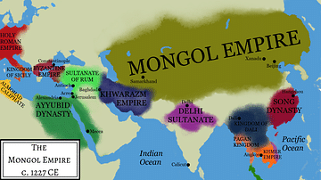
Map of the Mongol Empire: Conquests of Genghis Khan 1206-27 - From tribal unification to imperial rule across Eurasia

Mongol Empire Under Kublai Khan

Map of Yuan Dynasty China

Map of the Campaigns of Genghis Khan
Genghis Khan's Empire
Cite This Work
APA Style
Netchev, S. (2025, July 15). Map of the Four Khanates of the Mongol Empire, c. 1300. World History Encyclopedia. https://www.worldhistory.org/image/20677/map-of-the-four-khanates-of-the-mongol-empire-c-13/
Chicago Style
Netchev, Simeon. "Map of the Four Khanates of the Mongol Empire, c. 1300." World History Encyclopedia, July 15, 2025. https://www.worldhistory.org/image/20677/map-of-the-four-khanates-of-the-mongol-empire-c-13/.
MLA Style
Netchev, Simeon. "Map of the Four Khanates of the Mongol Empire, c. 1300." World History Encyclopedia, 15 Jul 2025, https://www.worldhistory.org/image/20677/map-of-the-four-khanates-of-the-mongol-empire-c-13/.