


This map illustrates the Roman Republic's territorial expansion from approximately 260 to 30 BCE, highlighting how a once-local power in central Italy transformed into a Mediterranean empire. From early campaigns in Sicily and Spain to sweeping conquests in the east and north, Rome grew through relentless warfare, strategic alliances, and the systematic incorporation of conquered lands into provinces.
Beginning as a regional confederation after the Latin War (340-338 BCE), the Republic steadily expanded, defeating Carthage in three Punic Wars (264-146 BCE), subduing Macedon and Greece (168-146 BCE), and eventually annexing Asia Minor, Syria, and Gaul. Each conflict left behind a network of provinces governed by Roman officials, while internal reforms and civil wars set the stage for the Republic’s transformation into an empire. The final act came with the annexation of Egypt (30 BCE) after the defeat of Cleopatra and Mark Antony, marking the end of the Republic and the dawn of imperial rule under Augustus.
About the Author

Related Images

Carthage during the Punic Wars

Map of the Rise and Fall of Carthage (c. 650-146 BCE)
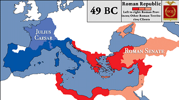
Roman Republic at the Beginning of Caesar's Civil War

The Second Punic War (218 - 201 BCE)

Map of the Provinces of the Roman Empire under Augustus

Map of the Roman Republic on the eve of the Mithridatic Wars
Cite This Work
APA Style
Netchev, S. (2022, December 05). Map of the Expansion of the Roman Republic (c. 260 - 30 BCE). World History Encyclopedia. https://www.worldhistory.org/image/16762/map-of-the-expansion-of-the-roman-republic-c-260/
Chicago Style
Netchev, Simeon. "Map of the Expansion of the Roman Republic (c. 260 - 30 BCE)." World History Encyclopedia, December 05, 2022. https://www.worldhistory.org/image/16762/map-of-the-expansion-of-the-roman-republic-c-260/.
MLA Style
Netchev, Simeon. "Map of the Expansion of the Roman Republic (c. 260 - 30 BCE)." World History Encyclopedia, 05 Dec 2022, https://www.worldhistory.org/image/16762/map-of-the-expansion-of-the-roman-republic-c-260/.