


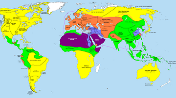
This map illustrates the changing patterns of Christian pilgrimage during the Middle Ages: for most Europeans the long, perilous, and costly journey to the Holy Land was too far, dangerous, and forbiddingly expensive, so devotion redirected toward nearer shrines. Routes now funneled the faithful to regional sanctuaries where relics of saints and martyrs promised spiritual merit closer to home.
Major alternatives emerged: Rome, seat of the Papacy, Santiago de Compostela in Christian Spain, Canterbury in Norman–Plantagenet England and countless local sites from Cologne to Kraków. Monasteries curated relics, towns prospered from pilgrims’ spending, and rulers such as Henry II of England (reigned 1154–1189) or Louis IX of France (reigned 1226–1270) endorsed new shrines to bolster piety and prestige. Thus medieval pilgrimage became a dense network of regional journeys, weaving spiritual practice into Europe’s economic and cultural landscape.
About the Author

Related Images

Map of the Early Christian Pilgrimage (4th-5th Century)

Map of Cnut the Great’s Pilgrimage to Rome in 1027 - Kingship, Faith, and Diplomacy Across Medieval Europe

Map of the World Known to Europeans in 1000 CE

Map of the Trade Networks in the Middle Ages, c. 1200
Map of the World in 1000 BCE

Map of Romani Migration in the Middle Ages
Cite This Work
APA Style
Netchev, S. (2022, July 04). Map of Christian Pilgrimage in the Middle Ages, c. 1000. World History Encyclopedia. https://www.worldhistory.org/image/16082/map-of-christian-pilgrimage-in-the-middle-ages-c-1/
Chicago Style
Netchev, Simeon. "Map of Christian Pilgrimage in the Middle Ages, c. 1000." World History Encyclopedia, July 04, 2022. https://www.worldhistory.org/image/16082/map-of-christian-pilgrimage-in-the-middle-ages-c-1/.
MLA Style
Netchev, Simeon. "Map of Christian Pilgrimage in the Middle Ages, c. 1000." World History Encyclopedia, 04 Jul 2022, https://www.worldhistory.org/image/16082/map-of-christian-pilgrimage-in-the-middle-ages-c-1/.