

This text is available in other languages:

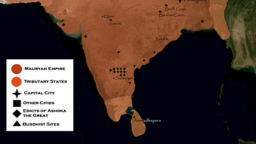
A map illustrating the rise and expansion of the Mauryan empire, the first pan-Indian empire that covered most of India and parts of present-day Iran. Chandragupta Maurya, the first ruler, seized the opportunity created by the power vacuum of Alexander the Great’s death to consolidate and expand the territory, while three generations later, emperor Ashoka turned to Buddhism and left his mark on history by inscribing numerous edicts (many of them encouraging peace and nonviolence) in stone.
About the Author

Related Images

Chandragupta Maurya's Empire

India in the Vedic Age, 1500 BCE-500 BCE

Robert Clive & The East India Company Rule in India, c. 1765

Map of India, 600 BCE
Mauryan Empire

Map of the Greek City-states c. 500 BCE
Cite This Work
APA Style
Netchev, S. (2022, May 20). Map of the Mauryan Empire, c. 321 - 185 BCE. World History Encyclopedia. https://www.worldhistory.org/image/15895/map-of-the-mauryan-empire-c-321---185-bce/
Chicago Style
Netchev, Simeon. "Map of the Mauryan Empire, c. 321 - 185 BCE." World History Encyclopedia, May 20, 2022. https://www.worldhistory.org/image/15895/map-of-the-mauryan-empire-c-321---185-bce/.
MLA Style
Netchev, Simeon. "Map of the Mauryan Empire, c. 321 - 185 BCE." World History Encyclopedia, 20 May 2022, https://www.worldhistory.org/image/15895/map-of-the-mauryan-empire-c-321---185-bce/.