

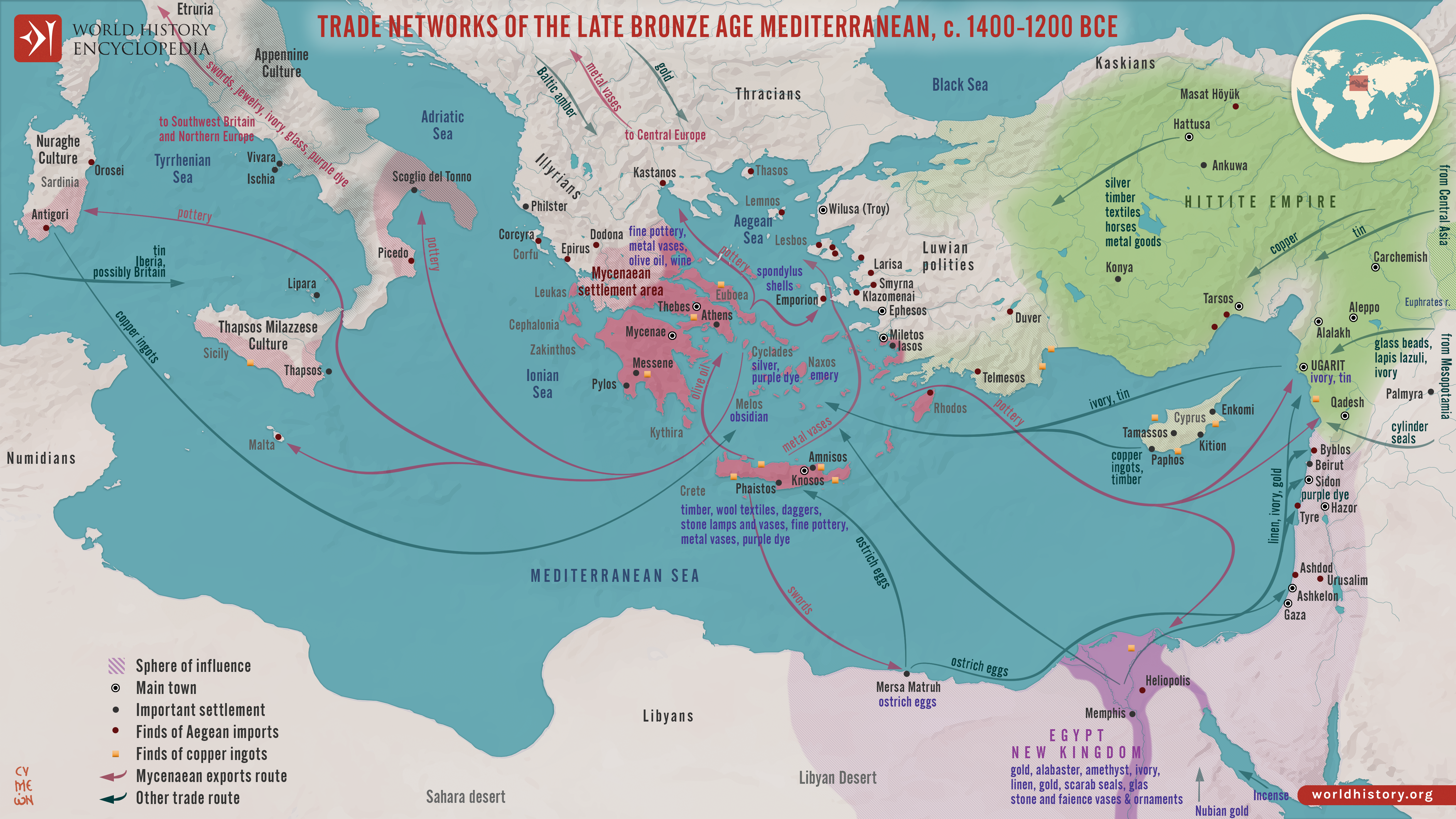
Between c. 1400 and 1200 BCE, the eastern Mediterranean and Aegean formed a densely interconnected system of exchange linking the Mycenaean palace states, New Kingdom Egypt, the Hittite Empire, Cyprus, Levantine city-states such as Ugarit, and kingdoms farther east in Mesopotamia. Maritime and overland routes carried copper from Cyprus, tin needed for bronze production, grain, timber, textiles, wine, olive oil, ceramics, ivory, glass, precious metals, and prestige goods. Commerce overlapped with diplomacy: documents such as the Amarna Letters reveal rulers exchanging gifts, arranging dynastic marriages, requesting valuable materials, and negotiating relationships within a wider international system.
These networks shaped political power and cultural change by moving people, technologies, artistic forms, religious ideas, and knowledge alongside commodities. Connections extended westward toward Sicily, Sardinia, and Italy and eastward through Anatolia and the Levant into Mesopotamia. Such interdependence also created vulnerabilities. Around 1200 BCE, interacting pressures, including warfare, political instability, population movements, environmental stress, and disruptions to long-distance exchange, contributed to the destruction or abandonment of many cities and the collapse of several palace-based political systems. The transformation was uneven rather than a single sudden collapse, but it profoundly reshaped Mediterranean societies and brought the Late Bronze Age international system to an end.
About the Author
Related Images

Map of the Mediterranean Trade Networks, c. 700–350 BCE - Commerce & Colonization in the Archaic and Classical Ages
Map of the Aegean Bronze Age Civilizations, c. 3000-1100 BCE - From Minoan Maritime Exchange to Mycenaean Dominance
Ptolemaic Trade Networks in the Late 1st Century BCE

Map of the Trade Networks of the Roman Empire - Commerce & the Connectivity in the Mediterranean 1-3 c. CE

Map of the Hanseatic League Trade Network, c. 1400

Map of Settlement & Mobility in the Aegean, c. 1100-550 BCE - Migration, Memory, and the Making of the Hellenic World
Cite This Work
APA Style
Netchev, S. (2026, September 27). Map of the Late Bronze Age Mediterranean Trade Networks: Trade, Diplomacy & Interdependence, c. 1400–1200 BCE. World History Encyclopedia. https://www.worldhistory.org/image/14880/map-of-the-late-bronze-age-mediterranean-trade-net/
Chicago Style
Netchev, Simeon. "Map of the Late Bronze Age Mediterranean Trade Networks: Trade, Diplomacy & Interdependence, c. 1400–1200 BCE." World History Encyclopedia, September 27, 2026. https://www.worldhistory.org/image/14880/map-of-the-late-bronze-age-mediterranean-trade-net/.
MLA Style
Netchev, Simeon. "Map of the Late Bronze Age Mediterranean Trade Networks: Trade, Diplomacy & Interdependence, c. 1400–1200 BCE." World History Encyclopedia, 27 Sep 2026, https://www.worldhistory.org/image/14880/map-of-the-late-bronze-age-mediterranean-trade-net/.
