
Search
Remove Ads
Advertisement
Search Results
Lesson Pack
Roman Economy & Trade
We have prepared three lesson plans including classroom activities, assignments, homework, and keys as well as: - Glossary of keywords and concepts in an excel format - Open questions adaptable for debates, presentations, and essays...

Definition
Portuguese Cochin
Cochin, located on the southwest coast of India, was a Portuguese colony from 1503 to 1663. Known to the Portuguese as Cochim, it was one of several important cities on India’s Malabar Coast and a great trade centre for spices like pepper...

Image
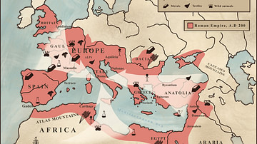
Map of the Trade Networks of the Ancient Mediterranean World - Connectivity & Expansion in the Archaic and Classical Ages
Between the 7th and 4th centuries BCE, the Mediterranean functioned as a highly interconnected zone of maritime exchange, shaped by the expanding networks of Phoenician and Hellenic communities. Originating from the Levant, Phoenician traders...

Definition
Silk Road
The Silk Road was a network of ancient trade routes, formally established during the Han Dynasty of China in 130 BCE, which linked the regions of the ancient world in commerce between 130 BCE-1453 CE. The Silk Road was not a single route...
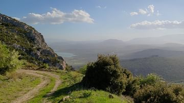
Image Gallery
A Panorama of Central Greece
The uniqueness of modern central Greece's landscape derives from the atmospheric blend of ancient archaeological sites and the Mediterranean flora. The forests are mostly composed of fir trees, pine trees, and bushes. These trees may be found...

Definition
Religion in the Ancient World - Order and the Spiritual Experience
Religion (from the Latin Religio, meaning "restraint," or Relegere, according to Cicero, meaning "to repeat, to read again," or, most likely, Religionem, "to show respect for what is sacred") is an organized system of beliefs and practices...

Definition
Ancient Celts
The ancient Celts were various tribal groups living in parts of western and central Europe in the Late Bronze Age and through the Iron Age (c. 700 BCE to c. 400 CE). Given the name Celts by ancient writers, these tribes and their culture...

Article
Roman Expeditions in Sub-Saharan Africa
Sub-Saharan Africa was explored by Roman expeditions between 19 BCE - 90 CE, most likely in an effort to locate the sources of valuable trade goods and establish routes to bring them to the seaports on the coast of North Africa, thereby minimizing...

Article
Tyrants of Greece
Tyrannies existed across the Greek world from the city-states to the islands of Sicily and Samos. Most historians date the Great Age of Greek Tyranny from 750 to 500 BCE, ending with the ousting of Hippias; however, some authors extend the...

Definition
Ancient Olympic Games
The ancient Olympic Games were a sporting event held every four years at the sacred site of Olympia, in the western Peloponnese, in honour of Zeus, the supreme god of the Greek religion. The games, held from 776 BCE to 393 CE, involved participants...