
Search
Remove Ads
Advertisement
Search Results

Definition
Ancient Syria
Syria is a country located in the Middle East on the shore of the Mediterranean Sea and bordered, from the north down to the west, by Turkey, Iraq, Jordan, Israel, and Lebanon. It is one of the oldest inhabited regions in the world with archaeological...
Definition
Ancient Dvin
Dvin (aka Duin), located 40 km south of modern Yerevan, was the capital of early medieval Armenia for four centuries. Founded in the 4th century CE, the city prospered and became the administrative head of the Armenian church. Remaining the...

Article
Battle of Karbala
The Battle of Karbala (10 October 680 CE) was a small-scaled military engagement, fought near the river Euphrates, in modern-day Iraq, which saw the massacre of heavily outnumbered Alid troops under the command of Husayn ibn Ali (l. 626-680...

Definition
Islam
Islam is an Abrahamic-monotheistic religion based upon the teachings of Prophet Muhammad ibn Abdullah (l. 570-632 CE, after whose name Muslims traditionally add “peace be upon him” or, in writing, PBUH). Alongside Christianity and Judaism...

Image
Map of the Islamic Conquests in the 7th-9th Centuries
This map illustrates the rise and rapid expansion of Islam from the time of the Prophet Muhammad (622–632 CE) through the great caliphates of the 7th to 9th centuries. Beginning in Arabia, the new faith and its armies spread under the Rashidun...

Image
Map of the First Fitna
Map of the conflict between Caliph Ali (r. 656-661 CE) and Muawiyah I (r. 661 – 680 CE) during the First Fitna (656 – 661 CE), a civil war within the Rashidun Caliphate. The area shaded in green represents the territories of the Caliphate...

Image
Expansion of Early Islamic Caliphates
This map shows the expansion of the Islamic Caliphates in the 7th and 8th Centuries CE: 1. Dark Shade: Expansion under the Prophet Muhammad, 622-632 CE. 2. Medium Shade: Expansion under the Rashidun Caliphate, 632-661 CE. 3. Light Shade...

Image
Khalid ibn al-Walid's Campaign in Arabia
Map detailing the route of the conquest of central Arabia by Khalid ibn al-Walid (585 - 642 CE) during the Ridda Wars, culminating in the decisive battle of Yamama (633 CE). Battles are shown as crossed swords (or scimitars) and the Rashidun...
Image
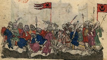
Illustration of the battle of Yarmouk (636 CE)
Illustration of the Battle of Yarmouk (636) at the bottom of the page of an early 14th Century CE manuscript. The forces of the Rashidun Caliphate are shown with a star and crescent banner, while the Byzantines are depicted with a star banner...
Image
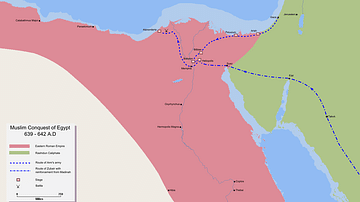
Muslim Conquest of Egypt, 640-642 CE
A map showing the conquest of Byzantine Egypt by the Rashidun Caliphate (640-642 CE), led by Amr ibn al-Aas and al-Zubayr ibn al-Awamm.