
Search
Remove Ads
Advertisement
Search Results
Image
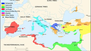
Map of the Mediterranean 218 BCE
A map of the Mediterranean in 218 BC, showing the territorial extents of the following states:
- Antigonids
- Attalids
- Carthage
- Ptolemies
- Roman Empire
- Seleucids
Major battle locations are also shown.

Image
Map of Trade Networks of the Late Bronze Age Mediterranean - Empires, Merchants, and Maritime Routes of the Ancient World
The Late Bronze Age eastern Mediterranean (c. 1500–1200 BCE) was marked by an unprecedented level of diplomatic and commercial interdependence among regional powers. Great kingdoms, including New Kingdom Egypt (c. 1550–1077 BCE), the Hittite...
Image
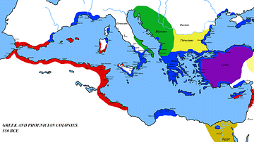
Map of the Mediterranean 550 BC
A map of the Mediterranean around 550 BC, showing the major cultures:
- Greece and its colonies
- Phoenicia and its colonies
- Lydia
- Egypt
- Persia
- Thrace
- Illyria

Image
The Western Mediterranean 264 BCE
Map of the western Mediterranean at the time of the First Punic War in 264 BCE.

Image
Bronze Age Mediterranean Invasions & Migrations
A map of the Late Bronze Age Mediterranean indicating the various invasions and migrations of the period.

Image
An Illustrated Map of the Mediterranean from 700 BCE to 500 CE (From the Novel "The Jericho River")
An illustrated map of the Mediterranean from 700 BCE to 500 CE. From the novel The Jericho River by David Tollen.

Image
Map of North Africa and the Western Mediterranean c. 1065 - Power Shifts in the Post-Caliphate Maghreb
Around 1065, the geopolitical landscape of North Africa and the western Mediterranean was marked by fragmentation, migration, and the rise of new regional powers. Older political structures were weakening, while emergent dynasties and mobile...

Image
476: The New Political Face of the Western Mediterranean
The map show the political situation within the western regions of the Mediterranean after the deposition of the last Western emperor, Romolus Augustulus, by Odoacer, the commander of the Italian imperial army. In reality, the Western Roman...

Image
Map of Eastern Mediterranean in 1450 CE
Geopolitical climate in the Eastern Mediterranean before the conquest of Constantinople in 1453 CE.

Image
Empires of the Mediterranean, 218 BCE.
A map showing the various empires throughout the Mediterranean in 218 BCE.