
Search
Remove Ads
Advertisement
Search Results
Definition
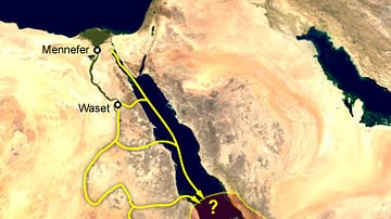
Punt
The Land of Punt was a region in Africa (most likely Somalia) referenced by inscriptions of ancient Egypt initially as a partner in trade and, later, as a semimythical country rich in resources and exotic goods. It is best known from the...

Definition
East India Company
The English East India Company (EIC or EEIC), later to become the British East India Company, was founded in 1600 as a trading company. With a massive private army and the backing of the British government, the EIC looted the Indian subcontinent...

Image
Map of the Trade Links between Rome & the East
The network popularly known as the Silk Road refers not to a single route but to a shifting constellation of overland and maritime pathways that connected East and West across more than a millennium. Long before the term was coined in the...

Article
European Discovery & Conquest of the Spice Islands
Clove, nutmeg, and mace are native to only a handful of tiny islands in the middle of the vast Indonesian archipelago – cloves on five Maluku Islands (the Moluccas) about 1250 km (778 mi) west of New Guinea, and nutmeg on the ten Banda Islands...

Image
Transatlantic Triangular Trade Map
Map showing the flow of goods and enslaved people across the Atlantic between Europe, Africa and America in the transatlantic triangular trade which the European colonial powers operated from the 16th to the 19th centuries CE. This triangular...

Image
Map of Medieval Japanese Trade & Wako Pirates
Map depicting Medieval Japan and its trade relations with its neighbours, China and Korea. The map shows the major trade goods exchanged between Japan, China, and Korea. Black lines show the approximate routes taken by the Wako Pirates. Each...

Video
Roman Trade with Africa DOCUMENTARY
We are continuing our new animated historical documentary series on the Roman trade and economy with a video on the trade with Africa. Previously we have covered the Roman trade with India https://www.youtube.com/watch?v=eDTaOOVbxLs and the...

Image
Map of Trade Networks of the Late Bronze Age Mediterranean - Empires, Merchants, and Maritime Routes of the Ancient World
The Late Bronze Age eastern Mediterranean (c. 1500–1200 BCE) was marked by an unprecedented level of diplomatic and commercial interdependence among regional powers. Great kingdoms, including New Kingdom Egypt (c. 1550–1077 BCE), the Hittite...

Definition
Songhai Empire
The Songhai Empire (aka Songhay, c. 1460 - c. 1591) covered what is today southern Mauritania and Mali. It replaced the Mali Empire (1240-1645) as the most important state in West Africa. Originating as a smaller kingdom along the eastern...

Image
Trans-Saharan Trade Routes
A map indicating the major trans-Saharan trade routes across West Africa c. 1100-1500 CE. The darker yellow areas indicate gold fields.