
Search
Remove Ads
Advertisement
Search Results

Image Gallery
4 Maps of Epic Ancient Quests
In this gallery, we cross the ancient Mediterranean world four times to follow the adventures of four great heroes from Greek and Roman mythology. Here are visual representations of timeless tales of heroism, divine challenges, and fearsome...
Image Gallery
Key Numbered Lists in History
Throughout history, societies and traditions have used numbered lists to categorize and structure key concepts, figures, and beliefs. These lists often serve as mnemonic devices, aiding in the transmission of cultural, religious, and political...

Image
Map of the Silk Road During the Late 8th Century
In the late 8th century CE, the interconnected caravan routes later termed the “Silk Road” formed a transcontinental system linking East Asia, Central Asia, the Islamic world, and parts of Europe. The label “Silk Road” (German: Seidenstraße...

Image
Map of Europe on the Eve of WWII, 1939
A map illustrating the growing instability in Europe in the lead-up to World War II, capturing the aggressive territorial expansion of Nazi Germany and the failure of appeasement. Between 1935 and 1939, a series of bold geopolitical moves...

Image
Map of Odysseus’ 10-year Journey Home
The Odyssey, traditionally attributed to Homer and composed around the 8th–7th century BCE, recounts the decade-long journey of Odysseus, king of Ithaca, as he attempts to return home after the Trojan War. Although set in a recognizable Mediterranean...

Image
House of Tudor Family Tree
An infographic illustrating the genealogy and royal succession of the House of Tudor that held the throne of England and its realms from 1485 to 1603. With predominantly Welsh origins in the male line, the dynasty descended from the Tudors...

Image
Map of the Achaemenid Persian Empire c. 500 BCE
The Achaemenid Persian Empire emerged in the mid-6th century BCE when Cyrus II (reign 559–530 BCE) united the Persian tribes and overthrew the Median kingdom (c. 550 BCE), establishing a new imperial state that would reshape the political...

Image
Map of the Fertile Crescent
The term “Fertile Crescent”, coined in 1916 by Egyptologist James Henry Breasted, refers to a broad arc of land stretching from the eastern Mediterranean through Anatolia and into Mesopotamia. Encompassing parts of today’s Iraq, Syria, Lebanon...

Image
Map of the Islamic Conquests in the 7th-9th Centuries
This map illustrates the rise and rapid expansion of Islam from the time of the Prophet Muhammad (622–632 CE) through the great caliphates of the 7th to 9th centuries. Beginning in Arabia, the new faith and its armies spread under the Rashidun...
Image
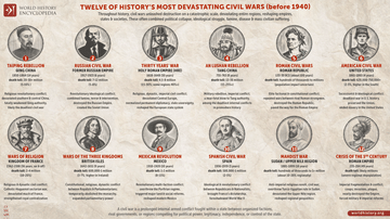
12 of History’s Most Devastating Civil Wars (before 1940) - Internal conflicts - shattered states & devastated societies
Civil wars have repeatedly emerged as some of the most destructive conflicts in human history because they combine military violence with political collapse, social fragmentation, famine, disease, and ideological struggle within already interconnected...