
Search
Remove Ads
Advertisement
Search Results
Image
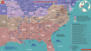
Map of the American Civil War, 1861-1865
The American Civil War (1861–1865) was a nationwide conflict in the United States sparked by the secession of eleven Southern states following Abraham Lincoln’s election in 1860. The Confederacy, founded on the preservation of slavery, clashed...

Image
The Feudal Society in Medieval Europe - Power in Medieval Europe: Lords, Land & the Church
The social structure of medieval Western Europe (c. 10th–13th centuries) is often described through the framework of feudal relationships and landholding systems that linked rulers, nobles, and rural communities. In this model, political...

Image
Map of the Voyages of Christopher Columbus 1492-1504
Christopher Columbus (c. 1451–1506) led four transatlantic expeditions between 1492 and 1504 under the patronage of Ferdinand II of Aragon and Isabella I of Castile. His goal was to find a westward maritime route to Asia’s trade centers...

Image
The Evolution of the Medieval King Arthur Legend - Merlin, Camelot, the Grail, and the Round Table
The Arthurian canon is a body of medieval legends, romances, chronicles, and poetic traditions centered on King Arthur, a semi-legendary ruler associated with post-Roman Britain and the defense of Britain against Saxon expansion. Emerging...

Image
Map of Europe Before the Fall of Constantinople, c. 1450
Around 1450 CE, Europe and the Middle East were defined by fragmentation, declining medieval powers, and the rise of new regional states. The Byzantine Empire had contracted to Constantinople and a few outposts, while the Ottoman Empire under...

Image
Map of the East India Company Trade, c.1800
The English East India Company (EIC) was established by Royal Charter on 31 December 1600 under Queen Elizabeth I (reign 1558–1603), granting it a monopoly on English trade east of the Cape of Good Hope. Initially conceived as a commercial...

Image
World War II in Europe, November 1942
A map depicting the strategic situation in Europe and the Mediterranean in early November 1942, as World War II reached a critical turning point. Axis expansion had begun to reverse, while the Allies launched major offensives in North Africa...

Image
Map of the Cradles of Early Civilization & Society - The First Centers of Agriculture, Complex Society & States
The pathways toward early civilization and complex society between c. 12,000 and 1000 BCE were neither uniform nor linear. After the end of the last Ice Age, climatic and environmental change encouraged communities in different parts of the...

Image
Map of Viking Exploration, 8th-11th Century
This map illustrates the sweep of Viking exploration between the late 8th and early 11th centuries, charting longship routes from Scandinavia to the British Isles, Normandy, Iberia, Russia, the Mediterranean, and across the North Atlantic...

Image
First-Wave / Earliest Civilizations
A map illustrating the earliest stages of human civilization spanning from c. 8000 BCE to 2000 BCE. It showcases the emergence of organized societies, agricultural practices, and the origins of urbanization.