
Search
Remove Ads
Advertisement
Search Results

Image
Map of North Africa and the Western Mediterranean c. 1065 - Power Shifts in the Post-Caliphate Maghreb
Around 1065, the geopolitical landscape of North Africa and the western Mediterranean was marked by fragmentation, migration, and the rise of new regional powers. Older political structures were weakening, while emergent dynasties and mobile...
Article
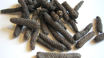
Middle Eastern Power Shifts & the Trade of Pepper from East to West
Pepper has long been the king of spices and for almost 2,000 years dominated world trade. Originating in India, it was known in Greece by the 4th century BCE and was an integral part of the Roman diet by 30 BCE. It remained a force in Europe...

Article
The Phoenicians - Master Mariners
Driven by their desire for trade and the acquisition of such commodities as silver from Spain, gold from Africa, and tin from the Scilly Isles, the Phoenicians sailed far and wide, even beyond the Mediterranean's traditional safe limits of...
Image
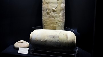
Dead Sea Scrolls Jars
Dead Sea Scrolls jars from Qumran (Khirbet Qumran or Wadi Qumran), West Bank of the Jordan River, near the north part of the Dead Sea, modern-day State of Israel. The Dead Sea Scrolls, or Qumran Caves Scrolls, are parchment and papyrus...

Image
Map of a Circumnavigation of the Black Sea c. 130 CE - Arrian of Nicomedia's "Periplus Ponti Euxini"
The Periplus Ponti Euxini (“Circumnavigation of the Black Sea”) by Arrian of Nicomedia (c. 86–after 146 CE) is a remarkable example of Roman geographical and administrative writing from the early 2nd century CE. The term Periplus, derived...

Article
Caesarea Maritima's Role in the Roman Empire
Caesarea Maritima, the city Herod the Great (r. 37-4 BCE) built for Rome on the southeastern coast of the Mediterranean served as the Roman Empire's powerbase of operations both commercially and militarily. With Rome's ultimate goal of adding...
Image
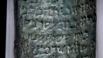
The Dead Sea's Copper Scroll
The Copper Scroll was discovered inside Cave 3 (Q3) at Qumran (Khirbat Qumran or Wadi Qumran). This is the only known inscription on metal from the Dead Sea area. The scroll originally consisted of three sheets of copper, totaling 2.3 meters...
Image
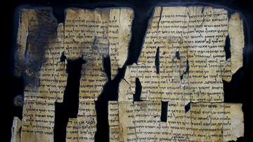
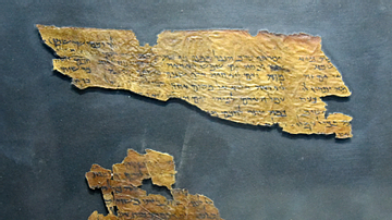
Dead Sea Scroll 28 from Qumran
This is Dead Sea Scroll number 28a (1Q28a), which was found in Cave 1 at Qumran (Khirbet Qumran or Wadi Qumran). The Dead Sea Scrolls are ancient Jewish religious manuscripts. The majority were written in Hebrew script on leather or papyrus...
Image
Dead Sea Scroll Qohelet from Qumran
This is Dead Sea Scroll number 4Q109, known as Qohelet (Ecclesiastes), which was found in Cave 4 at Qumran (Khirbet Qumran or Wadi Qumran). The Dead Sea Scrolls are ancient Jewish religious manuscripts. The majority were written in Hebrew...
Image
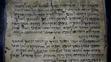
Dead Sea Scroll Testimonia from Qumran
Dead Sea Scroll number 175 (4Q175), which was found in Cave 4 at Qumran (Khirbet Qumran or Wadi Qumran), West Bank of the Jordan River, near the north part of the Dead Sea, modern-day State of Israel. It is also known as "The Testimonia"...