
Search
Remove Ads
Advertisement
Search Results

Interview
Interview: The Mysterious Bronze Age Collapse with Eric Cline
The decline of the Late Bronze Age civilizations of the Mediterranean and Near East has puzzled historians and archaeologists for centuries. While many have ascribed the collapse of several civilizations to the enigmatic Sea Peoples, Professor...

Image
Map of the North Sea Empire of Cnut the Great, 1016 - 1035 - England, Denmark, and Norway under a Viking Dynasty
The so-called North Sea Empire refers to the personal union created by Cnut the Great (reign in England 1016–1035; Denmark 1018–1035; Norway 1028–1035), which linked the kingdoms of England, Denmark, and Norway under a single ruler during...

Definition
Greek Colonization
From around 800 BCE, ancient Greek city-states, most of which were maritime powers, began to look beyond Greece for land and resources. As a consequence, they founded colonies across the Mediterranean. Trade was usually the first step in...
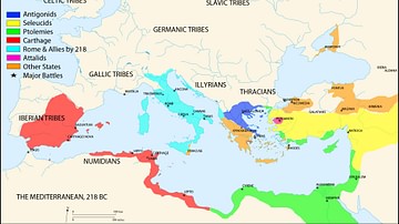
Image
Map of the Mediterranean 218 BCE
A map of the Mediterranean in 218 BC, showing the territorial extents of the following states:
- Antigonids
- Attalids
- Carthage
- Ptolemies
- Roman Empire
- Seleucids
Major battle locations are also shown.

Image
Map of Trade Networks of the Late Bronze Age Mediterranean - Empires, Merchants, and Maritime Routes of the Ancient World
The Late Bronze Age eastern Mediterranean (c. 1500–1200 BCE) was marked by an unprecedented level of diplomatic and commercial interdependence among regional powers. Great kingdoms, including New Kingdom Egypt (c. 1550–1077 BCE), the Hittite...
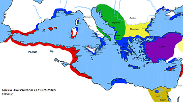
Image
Map of the Mediterranean 550 BC
A map of the Mediterranean around 550 BC, showing the major cultures:
- Greece and its colonies
- Phoenicia and its colonies
- Lydia
- Egypt
- Persia
- Thrace
- Illyria

Image
The Western Mediterranean 264 BCE
Map of the western Mediterranean at the time of the First Punic War in 264 BCE.
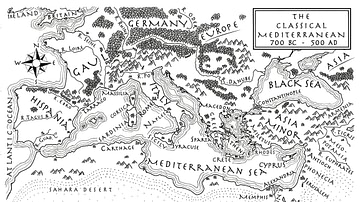
Image
An Illustrated Map of the Mediterranean from 700 BCE to 500 CE (From the Novel "The Jericho River")
An illustrated map of the Mediterranean from 700 BCE to 500 CE. From the novel The Jericho River by David Tollen.

Definition
Mycenaean Civilization
The Mycenaean civilization flourished in the Late Bronze Age (c. 1700-1100 BCE), peaking from the 15th to the 13th century BCE. The Mycenaeans extended their influence throughout the Peloponnese in Greece and across the Aegean from Crete...
Article
The Eastern Trade Network of Ancient Rome
The life of wealthy Romans was filled with exotic luxuries such as cinnamon, myrrh, pepper, or silk acquired through long-distance international trade. Goods from the Far East arrived in Rome through two corridors – the Red Sea and the Persian...