
Search
Remove Ads
Advertisement
Search Results
Image
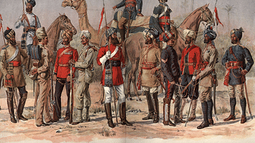
East India Company Madras Army
A 19th-century illustration showing officers and sepoys (Indian recruits) of the East India Company's Madras army.

Image
Dutch East India Company's Warehouse and Living Quarters
Dutch East India Company's warehouse and living quarters in Surat, India, as seen in April 1629 by Pieter van den Broecke (1585-1640), a Dutch cloth merchant in the service of the VOC.

Image
East India Company Trooper & Sepoy
An 1839 illustration showing a trooper and sepoy (Indian recruit) of the East India Company army. 27th Regiment of Madras Native Infantry. (British Library, London)

Definition
Wars of the Diadochi
On June 10, 323 BCE Alexander the Great died in Babylon. Although historians have debated the exact cause most agree that the empire he built was left without adequate leadership for there was no clear successor or heir. The military commanders...

Image
The Ancient Near East, c. 1300 BCE - On the Eve of Collapse: Power and Politics in the Late Bronze Age
This map illustrates the shifting political landscape of the Ancient Near East in the 13th century BCE, a period marked by the rise of imperial powers and the decline of older kingdoms. The expansion of the Hittite and Assyrian empires redrew...

Image
Map of the ancient Near East during the Amarna Period
Map of the ancient Near East during the Amarna Period, showing the great powers of the period: Egypt (green), Hatti (yellow), the Kassite kingdom of Babylon (purple), Assyria (grey), and Mittani (red). Lighter areas show direct control, darker...
Image
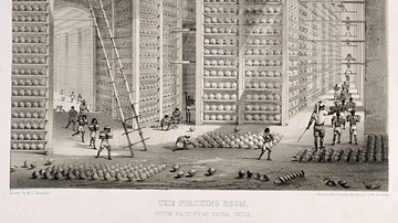
Opium Warehouse of the East India Company
A c. 1850 print showing an opium warehouse of the East India Company in Patna, India. Opium was dried into large balls and then packed into chests for transportation to China.

Image
Maji-Maji Rebellion, German East Africa
An early-20th-century painting by Wilhelm Kuhnert depicting German-led African Askari troops at the Battle of Mahenge during the Maji-Maji Rebellion (1905-7) against colonial rule in German East Africa.

Image
Dutch East India Company Logo
Blue and white Dutch East India Company (Vereenigde Oostindische Compagnie or VOC) logo from 1650-1674. Made in Japan to order by the company's directors in Batavia (Jakarta). Date between 1615 and 1674.

Image
Pieter de Carpentier - Governor General of the Dutch East Indies
Pieter de Carpentier (1586-1659) - Governor General of the Dutch East Indies.