
Search
Remove Ads
Advertisement
Search Results

Image
Jan Pieterszoon Coen, Governor General of the Dutch East Indies
Jan Pieterszoon Coen (1587-1629), an officer of the Dutch East India Company and twice the company's Governor-General in the Dutch East Indies, oil on wood portrait after Jacob Waben, 1629.
Westfries Museum, Hoorn, The Netherlands.
![Chogha Zanbil Ziggurat [East Side], Iran](https://www.worldhistory.org/img/c/p/360x202/10670.jpg?v=1779796397)
Image
Chogha Zanbil Ziggurat [East Side], Iran
View of the east side of the ziggurat of Chogha Zanbil with the southeastern stairway which provided access to the first terrace. Chogha Zanbil is a magnificent, 3300-year-old ancient Elamite complex located 30 kilometres south-east of the...

Video
A New History of the Ancient Near East with Amanda Podany
Weavers, Scribes, and Kings: A New History of the Ancient Near East by Amanda H. Podany is a unique history of the ancient Near East that compellingly presents the life stories of kings, priestesses, merchants, bricklayers, and others. Rather...

Image
East Pagoda, Yakushiji
The East Pagoda of Yakushiji temple, Nara, Japan. The three-story pagoda is original and dates to the 8th century CE and rises to a height of 33 metres (108 ft).
Image
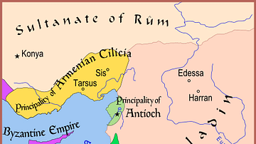
Map of The Latin East, 1190 CE
A map of the Middle East showing the Crusader-held Latin East states at the time of the Third Crusade (1189-1192 CE).

Image
Map of Mesopotamia and the Ancient Near East, c. 1300 BCE
Map of Mesopotamia and the Ancient Near East c. 1300 BCE, showing the period of Great Powers, with the six large kingdoms and empires (the Hittites, the Mycenaean Civilization, Assyria, Babylonia, Elam and the New Kingdom of Egypt) co-existing...
Image
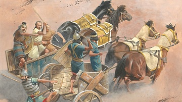
Chariot Warfare in the Ancient Near East
An illustration of what chariot warfare looked like in the ancient Near East. Illustration by by Zvonimir Grbasic.

Image
Weavers, Scribes, and Kings: A New History of the Ancient Near East by Amanda H. Podany
Weavers, Scribes, and Kings: A New History of the Ancient Near East by Amanda H. Podany

Definition
Marco Polo
Marco Polo (1254-1324 CE) was a Venetian merchant and explorer who travelled to China and served the Mongol ruler Kublai Khan (l. 1214-1294 CE) between c. 1275 and 1292 CE. Polo's adventures are recounted in his own writings, The Travels...

Image
Parthenon, East Facade
East facade of the Parthenon, Athens, 5th century BCE.