
Search
Remove Ads
Advertisement
Search Results

Image
The Near East in 1135 CE
This map of the Near East in 1135 CE shows four Crusader States (marked with red crosses) in relation to other powerful kingdoms in the period between the first and second crusades.

Image
East Pediment of the Parthenon
The left section of the east pediment of the Parthenon. On the far left Helios and his chariot rise from the base of the pediment, next is Dionysos reclining, then the figures are female deities, possibly Demeter, Kore and Artemis. (British...

Image
Athena (after the East pediment of the Parthenon)
A Pentelic marble statue of Athena considered to be similar to that originally on the East pediment of the Parthenon. The statue was dedicated to Artemis, mid-3rd century CE. (National Archaeological Museum, Athens)

Image
East Roman Empire, 6th century CE
East Roman Empire, 6th century CE, showing the territories of the Avars, Goths, Franks, Lombards, Saxons, Thuringians, Slavs.

Image
Map of East Frisia
Map of East Frisia by the Dutch Johannes Florianus (1522-1585) for the Theatrum Orbis Terrarum, one of the first accurate modern atlas, 1595.

Image
Traditional Scythian-Occupied Region East of Ukraine
A map of the traditional areas inhabited by the Scythians, stretching east from the Ukraine.

Image
The East India House Inscription
Building Babylon: this inscribed stone was found at the ruins of Babylon and described the religious devotion and civic achievement of king Nebuchadnezzar II. The long inscription records that as well as building the Processional Way and...
Image
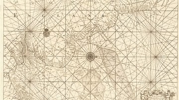
Map of the East Coast from the River Thames to Edinburgh
Map of the East Coast from the River Thames to Edinburgh, from Great Britain's Coasting Pilot,ink on paper by Greenville Collins, c. 1682-1694. Probably drafted in 1682 but not published until 1693, this chart is the first to show with accuracy...

Image
Emperor Charles the Fat & King Louis III the Younger of East Francia
Engraved portrait of Kings of East Francia Charles the Fat (r. 876-887 CE), Holy Roman Emperor (r. 881-887 CE), and Louis III the Younger (r. 876-882 CE), by unknown creator, c. 1634-1643 CE.
The British Museum, London.
Image
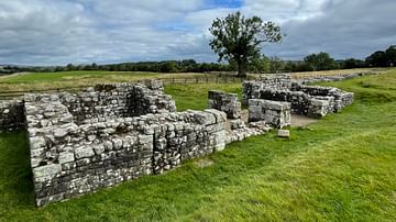
Birdoswald Roman Fort, East Gate
The remains of the east gate (porta principalis dextra) of Birdoswald fort, the best-preserved fort gateway on Hadrian's Wall.