
Search
Remove Ads
Advertisement
Search Results

Collection
The History of The East India Company
The British East India Company (EIC) was founded as a trading company in 1600. Run by a board of directors in London, the company employed a private army, first to protect the trade it conducted in the Indian subcontinent and then to expand...

Article
Conflict & Celts: The Creation of Ancient Galatia
Galatia was the most long-lasting and powerful Celtic settlement outside of Europe. It was the only kingdom of note to be forged during the Celtic invasions of the Mediterranean in the 4th and 3rd centuries BCE. From its foundation, Galatia...

Article
The Spice Trade & the Age of Exploration
One of the major motivating factors in the European Age of Exploration was the search for direct access to the highly lucrative Eastern spice trade. In the 15th century, spices came to Europe via the Middle East land and sea routes, and spices...
Image
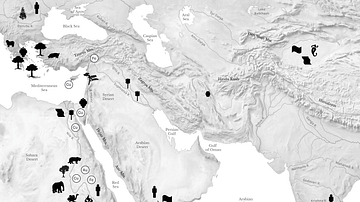
Resource Map of the Ancient Middle East
Map showing some of the major regional resouces of the eastern Mediterranean, the Near East, East Africa, and Central and South Asia.

Collection
The Civilizations of the Near East, The People of Mesopotamia
This collection focuses on providing supplementary materials to students who want to enhance their school history studies and to teachers who want a more concise coverage of each lesson that they deliver. This chapter examines the economic...

Definition
Portuguese Goa
Goa, located on the west coast of India, was a Portuguese colony from 1510 to 1961. The small coastal area was conquered by Afonso de Albuquerque (c. 1453-1515) and became an important trade hub for the Eastern spice trade. Goa was the capital...

Article
Origins of World Agriculture
Agriculture arose independently at several locations across the world, beginning about 12,000 years ago. The first crops and livestock were domesticated in six rather diffuse areas including the Near East, China, Southeast Asia, and Africa...

Article
Cultural Links between India & the Greco-Roman World
Cyrus the Great (558-530 BCE) built the first universal empire, stretching from Greece to the Indus River. This was the famous Achaemenid Empire of Persia. An inscription at Naqsh-i-Rustam, the tomb of his able successor Darius I (521-486...

Image
Map of Tthe Ancient Near East c. 1700 BCE - The Old Assyrian Empire - between cities and kingdoms
Around c. 1700 BCE, the Ancient Near East was a politically fragmented but highly interconnected region, shaped by shifting alliances, commercial networks, and emerging territorial states. This period corresponds to the Old Assyrian era and...

Image
Map of the East India Company Trade, c.1800
The English East India Company (EIC) was established by Royal Charter on 31 December 1600 under Queen Elizabeth I (reign 1558–1603), granting it a monopoly on English trade east of the Cape of Good Hope. Initially conceived as a commercial...