
Browse Content

Image
Map of the British Conquest in India c. 1857
This map illustrates the rapid and often chaotic expansion of British control in India between the Battle...

Image
Map of the Hanseatic League Trade Network, c. 1400
The Hanseatic League (c. 13th–17th centuries) was a powerful network of merchant guilds and cities...

Image
Map of the Carolingian Empire under Charlemagne, c. 814
The rise and expansion of the Carolingian dynasty (8th–early 9th centuries CE) reached its apex...
Image
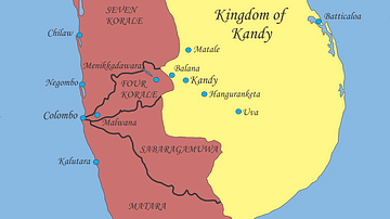
Sri Lanka, Early 17th Century
Political situation in Sri Lanka, early 17th century.

Image
Map of Spanish Conquest & Exploration in North America
This map illustrates the expansion of Spanish imperial power following the completion of the Reconquista...

Image
Map of the Quest of Jason and the Argonauts
This map follows the legendary voyage of Jason and the Argonauts, one of the great epic tales of Greek mythology...
