
Browse Content

Image
Map of Christian Pilgrimage in the Middle Ages, c. 1000
This map illustrates the changing patterns of Christian pilgrimage during the Middle Ages: for...

Image
Viceroyalty of New Spain, c. 1800
This map illustrates the Viceroyalty of New Spain, the earliest and most extensive administrative division of the...
Image
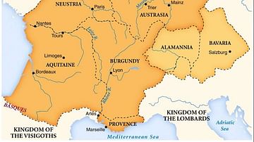
Merovingian Kingdoms
Map of the Merovingian kingdoms at their height.

Image
Map of East Frisia
Map of East Frisia by the Dutch Johannes Florianus (1522-1585) for the Theatrum Orbis Terrarum, one of the first accurate modern...

Image
Map of the Early Christian Pilgrimage (4th-5th Century)
The rise of Christian pilgrimage begins after the conversion of Emperor Constantine (reign 306–337...

Image
Map Showing Davis Island Below the Tropic of Capricorn
Ile Davis (Davis Island or Davis Land) was an island said to have been discovered in 1687 near...
