Server Costs Fundraiser 2024
Illustration
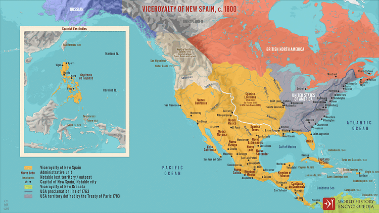
A map depicting the Viceroyalty of New Spain (the first of four viceroyalties that the Spanish Crown established to govern its conquests) which, at its height, comprised five royal audiencias and over twelve Catholic dioceses covering vast and diverse territories that included present-day Mexico, Central America, Cuba, Santo Domingo, Puerto Rico, Florida, the Midwest and Southwest of the United States, California, and the Philippines. Established soon after the conquest of the Aztecs in 1521, New Spain endured until the rise of the Mexican Empire of Agustín de Iturbide in 1821.
About the Author
Cite This Work
APA Style
Netchev, S. (2022, July 01). Viceroyalty of New Spain, c. 1800. World History Encyclopedia. Retrieved from https://www.worldhistory.org/image/16081/viceroyalty-of-new-spain-c-1800/
Chicago Style
Netchev, Simeon. "Viceroyalty of New Spain, c. 1800." World History Encyclopedia. Last modified July 01, 2022. https://www.worldhistory.org/image/16081/viceroyalty-of-new-spain-c-1800/.
MLA Style
Netchev, Simeon. "Viceroyalty of New Spain, c. 1800." World History Encyclopedia. World History Encyclopedia, 01 Jul 2022. Web. 26 Jul 2024.


