
Search Images
Browse Content (p. 114)

Image
Battleship Potemkin, 1905
Sailors of the Russian battleship Potemkin, based in Odessa, staged a mutiny in June 1905 as part of the Revolution of 1905 against Tsar Nicholas II (Reign 1894-1917)

Image
Paganini's Violin
The violin of Niccolò Paganini (1782-1840) exhibited in the Paganini room at the Palazzo Doria-Tursi, Italy.
Musei di Strada Nuova, Genoa, Italy.

Image
Map of the Pô Department
This antique map of Italy depicts the department of the Pô under the First French Empire. It was created in the early 19th century by French geographer Pierre-Gilles Chanlaire and is part of the Atlas National de France. The map illustrates...

Image
Map of the Rhin-et-Moselle Department
This antique map of Germany represents the department of Rhin-et-Moselle under the First French Empire. It was produced in the early 19th century by French geographer Pierre-Gilles Chanlaire and is included in the Atlas National de France...

Image
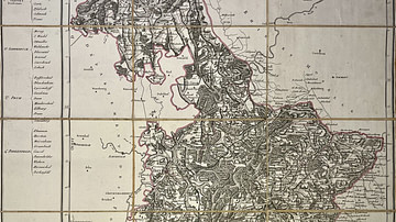
Map of the Roer Department
This antique map of Germany depicts the department of the Roer during the First French Empire. It was created in the early 19th century by French geographer Pierre-Gilles Chanlaire and is part of the Atlas National de France. The map documents...

Image
Map of the Sambre-et-Meuse Department
This antique map of Belgium shows the department of Sambre-et-Meuse under the First French Empire. It was created in the early 19th century by French geographer Pierre-Gilles Chanlaire and forms part of the Atlas National de France. The map...
Image
Map of the Saar Department
This antique map of Germany depicts the department of the Saar under the First French Empire. It was produced in the early 19th century by French geographer Pierre-Gilles Chanlaire and is part of the Atlas National de France. The map illustrates...
Image
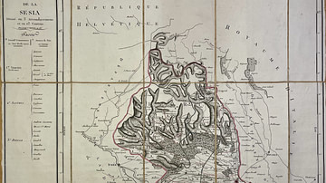
Map of the Sesia Department
This antique map of Italy shows the department of Sesia under the First French Empire. It was created in the early 19th century by French geographer Pierre-Gilles Chanlaire and is part of the Atlas National de France. The map reflects the...
Image
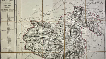
Map of the Stura Department
This antique map of Italy depicts the First French Empire’s department of Stura. Created in the early 19th century by French geographer Pierre-Gilles Chanlaire, it is part of the Atlas National de France. The map reflects the administrative...
Image
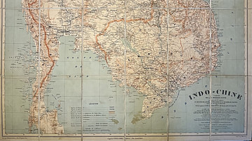
Map of Indochina by the Pavie Mission
This antique map of Indochina, dated 1909, was produced under the direction of Auguste Pavie and based on surveys carried out by members of the Pavie Mission between 1880 and 1895. It was created under the auspices of the French Ministry...