


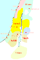
A map of Palestine circa 830 BC, showing the kingdoms of Israel and Judah, as well as the surrounding kingdoms and tribes.
Related Images
Map of Ancient Israel

Satellite Image of Canaan-Palestine-Israel

Map of the Herodian Tetrarchy in the Levant, c. 5 CE

Map of Southern Levant c.1200 BCE - Emerging Societies in the Early Iron Age
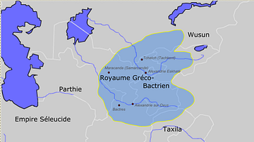
Greco-Bactrian kingdom circa 230-200 BC

Map of Canaan
Cite This Work
APA Style
Richardprins. (2012, April 26). Map of the Levant circa 830 BCE. World History Encyclopedia. https://www.worldhistory.org/image/285/map-of-the-levant-circa-830-bce/
Chicago Style
Richardprins. "Map of the Levant circa 830 BCE." World History Encyclopedia, April 26, 2012. https://www.worldhistory.org/image/285/map-of-the-levant-circa-830-bce/.
MLA Style
Richardprins. "Map of the Levant circa 830 BCE." World History Encyclopedia, 26 Apr 2012, https://www.worldhistory.org/image/285/map-of-the-levant-circa-830-bce/.