


A satellite image of the region of the eastern Mediterranean variously known as Canaan, Phoenicia, Palestine and Israel throughout history.
Related Images

Satellite Image of Africa's Great Lakes
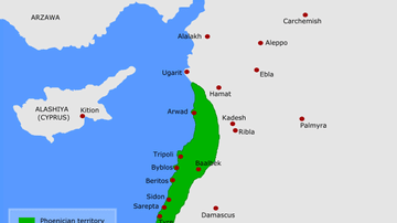
Map of Phoenicia

Assyrian Chariots in Phoenicia and the Storming of Khazazu

Map of Canaan

New English Canaan

Image from The Book of the Heavenly Cow
Cite This Work
APA Style
NASA. (2018, October 25). Satellite Image of Canaan-Palestine-Israel. World History Encyclopedia. https://www.worldhistory.org/image/9382/satellite-image-of-canaan-palestine-israel/
Chicago Style
NASA. "Satellite Image of Canaan-Palestine-Israel." World History Encyclopedia, October 25, 2018. https://www.worldhistory.org/image/9382/satellite-image-of-canaan-palestine-israel/.
MLA Style
NASA. "Satellite Image of Canaan-Palestine-Israel." World History Encyclopedia, 25 Oct 2018, https://www.worldhistory.org/image/9382/satellite-image-of-canaan-palestine-israel/.