


A map of the cradles of early civilization. The pathways toward early civilization between c. 12,000 and 1,000 BCE were neither uniform nor linear. In the wake of the last Ice Age, climatic change encouraged communities in different parts of the world to experiment independently with cultivation, domestication, and increasingly settled ways of life. Over long timescales, these experiments produced diverse forms of social complexity shaped by local environments and resources, rather than a single, universal model of development.
Across regions such as the Fertile Crescent, the Nile Valley, the Indus, and the Yellow and Yangtze river basins, some societies moved toward urban centers, centralized authority, and dynastic rule. Elsewhere, complex societies emerged without cities or formal states, sustained instead by ritual landscapes, long-distance exchange, and layered social hierarchies. Independent agricultural traditions in the Americas, Africa, New Guinea, and East Asia underscore that “civilization” took many forms. Human societies confronted similar challenges but responded in different ways, producing multiple, parallel routes to achieve an ever more complex culture.
About the Author

Related Images

Map of the Fertile Crescent
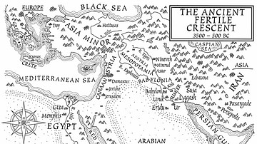
A Map of the Ancient Fertile Crescent (From the Novel The Jericho River)
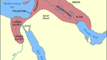
Map of the Fertile Crescent

Fertile Crescent Map

Map of the Indus Valley Civilization, c. 3300-1300 BCE - Cities, Trade, and Settlement in the Bronze Age

Indus Valley Civilization - Mature Harappan Phase
Cite This Work
APA Style
Netchev, S. (2026, January 23). Map of the Cradles of Early Civilization: Global Pathways to Agriculture, Urban Centers & Early States. World History Encyclopedia. https://www.worldhistory.org/image/21507/map-of-the-cradles-of-early-civilization/
Chicago Style
Netchev, Simeon. "Map of the Cradles of Early Civilization: Global Pathways to Agriculture, Urban Centers & Early States." World History Encyclopedia, January 23, 2026. https://www.worldhistory.org/image/21507/map-of-the-cradles-of-early-civilization/.
MLA Style
Netchev, Simeon. "Map of the Cradles of Early Civilization: Global Pathways to Agriculture, Urban Centers & Early States." World History Encyclopedia, 23 Jan 2026, https://www.worldhistory.org/image/21507/map-of-the-cradles-of-early-civilization/.