
Illustration


This map illustrates the situation in the United States n 1850, as the country faced growing sectional tension over the expansion of slavery into new territories gained from the Mexican-American War. The Compromise of 1850 aimed to preserve the Union by balancing interests between free and slave states through a series of legislative acts.
The compromise admitted California as a free state, while allowing the territories of New Mexico and Utah to decide on slavery by popular sovereignty. It also included a stricter Fugitive Slave Act, fueling Northern resistance, and settled a border dispute in favor of Texas in exchange for federal debt relief. The slave trade was abolished in Washington, D.C., though slavery itself remained legal there. While the Compromise temporarily eased tensions, it exposed deep divisions and laid the groundwork for future conflict, showing that legislative balancing acts could no longer hold back the growing national crisis over slavery.
About the Author

Related Images

Map of the United States on the Eve of Civil War, 1861 - Free States, Slave States, and the Fracturing of the Union
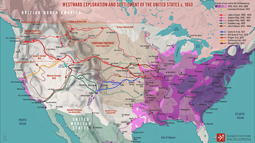
Westward Exploration and Settlement of the United States c.1850
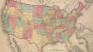
Map of the United States, 1874
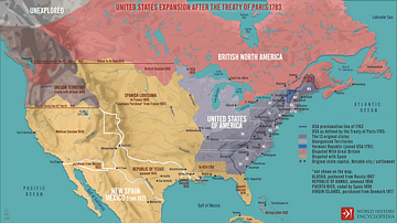
United States Expansion after the Treaty of Paris in 1783

Map of the World in the 14th Century

Map of the Roman Civil War (49 - 45 BCE) - Caesar, Pompey, and the Fall of the Republic
Cite This Work
APA Style
Netchev, S. (2025, June 04). Map of the United States Under the Compromise of 1850. World History Encyclopedia. Retrieved from https://www.worldhistory.org/image/20534/map-of-the-united-states-under-the-compromise-of-1/
Chicago Style
Netchev, Simeon. "Map of the United States Under the Compromise of 1850." World History Encyclopedia. Last modified June 04, 2025. https://www.worldhistory.org/image/20534/map-of-the-united-states-under-the-compromise-of-1/.
MLA Style
Netchev, Simeon. "Map of the United States Under the Compromise of 1850." World History Encyclopedia. World History Encyclopedia, 04 Jun 2025, https://www.worldhistory.org/image/20534/map-of-the-united-states-under-the-compromise-of-1/. Web. 01 Jul 2025.