

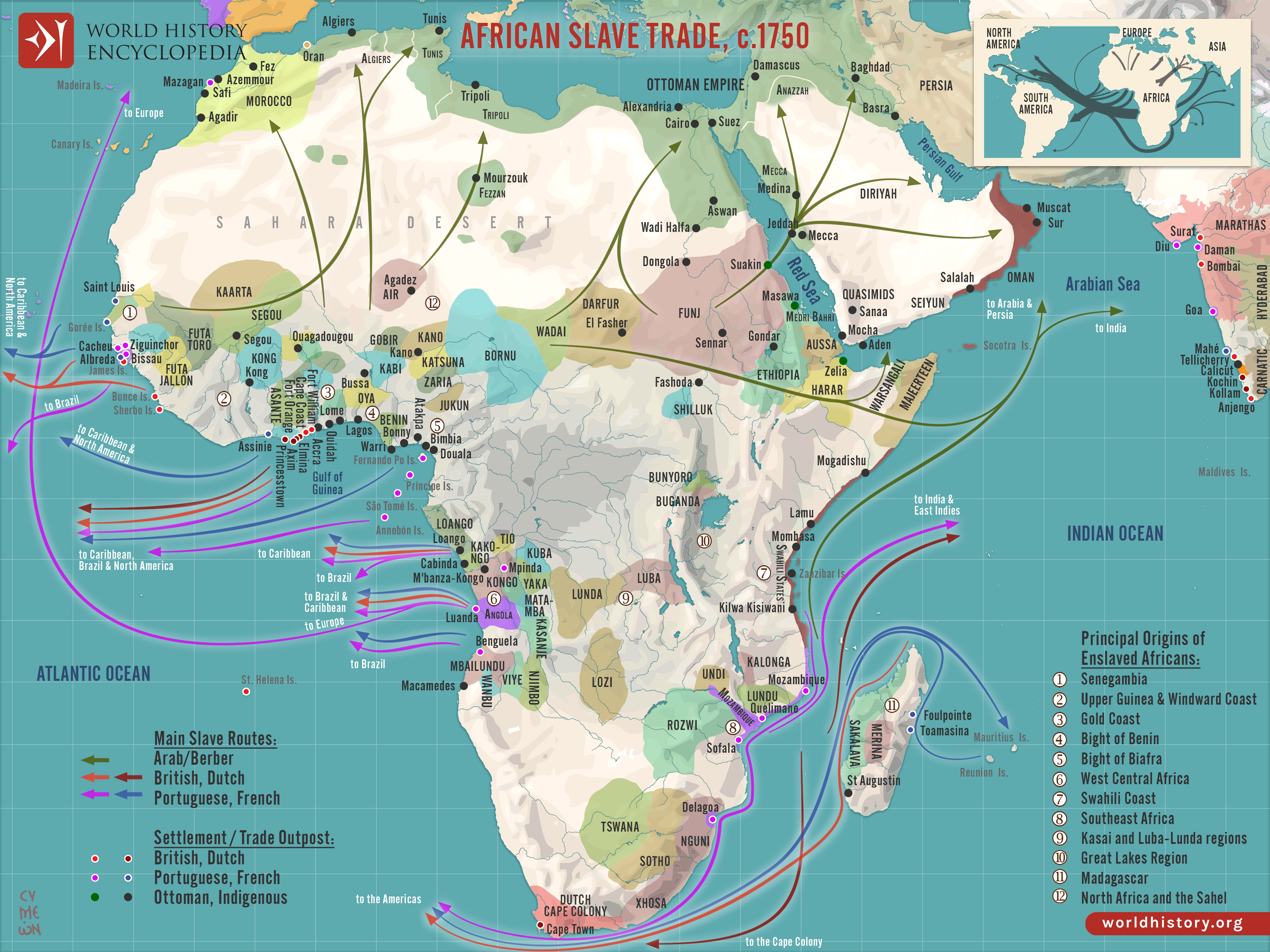
By c. 1750, Africa stood at the center of three major slave-trading systems, the transatlantic, trans-Saharan, and Indian Ocean trades, each connecting African societies to wider global economies. These networks operated simultaneously but unevenly across regions, drawing in West Africa, Central Africa, the Sahel, and the Swahili Coast through shifting political alliances, warfare, and commercial incentives. The scale and direction of each trade reflected long-term regional dynamics as well as the expanding economic ambitions of European, Middle Eastern, and Asian powers.
In West and Central Africa, the transatlantic slave trade became dominant, driven by European demand for plantation labor in the Americas. States such as Dahomey, Oyo, and Kongo captured and sold captives in exchange for firearms, textiles, alcohol, and manufactured goods, while coastal hubs like Elmina and Luanda functioned as major export centers. On the Swahili Coast, merchants from Zanzibar, Kilwa, and Mombasa traded enslaved people across the Indian Ocean to Arabia, Persia, and India, continuing older commercial links. Meanwhile, trans-Saharan routes connected inland powers, including the Bornu Empire and Hausaland, to North African markets in Tripoli, Tunis, and Cairo. Together, these systems reshaped African political economies: some states centralized and expanded through participation, others experienced intensified warfare and raiding, and many regions reoriented toward export-driven structures. The combined effect was a profound redistribution of power, population, and economic resources across the continent.
About the Author

Related Images

Transatlantic Triangular Trade Map

Map of the Châteaux of the Loire Valley, c.1750

Map of the European Colonization of North America, 1492-1750

Map of New France, 1750 CE
Map of Goa, c. 1750

Map of Africa in World War II
Cite This Work
APA Style
Netchev, S. (2025, April 08). Map of the African Slave Trade, c. 1750. World History Encyclopedia. https://www.worldhistory.org/image/20311/map-of--the-african-slave-trade-c-1750/
Chicago Style
Netchev, Simeon. "Map of the African Slave Trade, c. 1750." World History Encyclopedia, April 08, 2025. https://www.worldhistory.org/image/20311/map-of--the-african-slave-trade-c-1750/.
MLA Style
Netchev, Simeon. "Map of the African Slave Trade, c. 1750." World History Encyclopedia, 08 Apr 2025, https://www.worldhistory.org/image/20311/map-of--the-african-slave-trade-c-1750/.