
7 days left
Server Costs Fundraiser 2026
It costs $20,000 a year to run our servers, and we need your help to pay for them!
$11416 / $20000


A map of New France c. 1750 CE within the context of European colonies in North America.
Related Images

Image
Map of the European Colonization of North America, 1492-1750
The systematic European colonization of North America unfolded...

Image
Map of the Châteaux of the Loire Valley, c.1750
This map illustrates the Castles of the Loire, or Châteaux de la...
Image
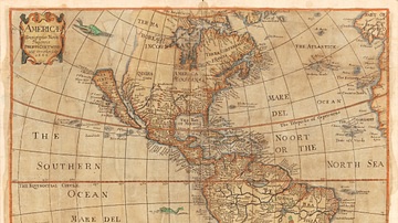
Map of the Americas, 1666 CE
"Americæ descriptio nova", a map of the Americas in 1666 CE. Made...

Image
Map of the African Slave Trade, c. 1750
By c. 1750, Africa stood at the center of three major slave-trading...
Image
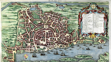
Map of Goa, c. 1750
A c. 1750 map of Portuguese Goa in India, capital of the Estado...
Image
Map of New France, 1612 CE
Map of New France 1612 CE by Samuel de Champlain (1567?-1635 CE...
Cite This Work
APA Style
Pinpin. (2021, March 26). Map of New France, 1750 CE. World History Encyclopedia. https://www.worldhistory.org/image/13729/map-of-new-france-1750-ce/
Chicago Style
Pinpin. "Map of New France, 1750 CE." World History Encyclopedia, March 26, 2021. https://www.worldhistory.org/image/13729/map-of-new-france-1750-ce/.
MLA Style
Pinpin. "Map of New France, 1750 CE." World History Encyclopedia, 26 Mar 2021, https://www.worldhistory.org/image/13729/map-of-new-france-1750-ce/.