


The Roman incorporation of Gaul began with the campaigns of Julius Caesar (58–51 BCE) and resulted in the gradual transformation of a diverse Celtic region into an integral part of the Roman world. By c. 200 CE, Gaul was organized into a structured provincial system including Gallia Narbonensis, Gallia Lugdunensis, Gallia Belgica, and the frontier provinces of Germania Inferior and Germania Superior. These northern provinces were closely tied to the Limes Germanicus, the fortified frontier along the Rhine that marked both a military boundary and a zone of interaction with non-Roman peoples. This administrative framework reflects the broader Roman approach to governance: combining direct rule, local elites, and military presence to secure stability and integrate newly conquered territories.
Over the following two centuries, Roman rule reshaped Gaul through urbanization, infrastructure, and cultural exchange. Major centers such as Lugdunum (Lyon) emerged as administrative capitals and hubs of imperial authority, while an extensive network of roads facilitated trade, communication, and troop movement. The spread of Latin language, Roman law, and civic institutions coexisted with enduring local traditions, producing a distinctive Gallo-Roman culture. Economically, Gaul became a vital region for agriculture, artisanal production, and military recruitment.
About the Author

Related Images

Roman Province Bithynia et Pontus c. 200 CE
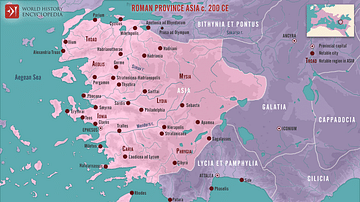
Roman Province Asia c. 200 CE

Map of Gaul
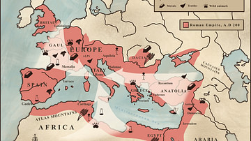
Trade in the Roman Empire Map (c. 200 CE)

Map of the Roman Province of Galatia
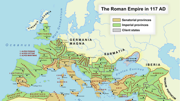
Roman Empire in 117 CE
Cite This Work
APA Style
Netchev, S. (2025, January 16). Map of Roman Gaul from Conquest to Integration, c. 200 CE: Provincial Order and Frontier Power in the Roman West. World History Encyclopedia. https://www.worldhistory.org/image/19880/map-of-roman-gaul-from-conquest-to-integration-c-2/
Chicago Style
Netchev, Simeon. "Map of Roman Gaul from Conquest to Integration, c. 200 CE: Provincial Order and Frontier Power in the Roman West." World History Encyclopedia, January 16, 2025. https://www.worldhistory.org/image/19880/map-of-roman-gaul-from-conquest-to-integration-c-2/.
MLA Style
Netchev, Simeon. "Map of Roman Gaul from Conquest to Integration, c. 200 CE: Provincial Order and Frontier Power in the Roman West." World History Encyclopedia, 16 Jan 2025, https://www.worldhistory.org/image/19880/map-of-roman-gaul-from-conquest-to-integration-c-2/.