


The Roman Levant around 200 CE, during the height of imperial consolidation under the Severan dynasty (193 - 235 CE), formed one of the empire’s most dynamic and interconnected frontier regions. Administratively divided into the provinces of Syria Coele, Syria Phoenice, Judea (renamed Syria Palaestina), and Arabia Petraea, the region held immense strategic and commercial significance, linking the Mediterranean basin with Mesopotamia, Arabia, and Egypt. The Roman presence built on centuries of Hellenistic urbanism, producing a complex cultural mosaic that integrated Roman governance with Greek, Jewish, and Semitic traditions.
Economically and culturally, the Levant was a vital crossroads of empire. Major cities such as Antioch, Berytus (Beirut), Aelia Capitolina (Jerusalem), and Caesarea Maritima thrived as centers of administration, trade, and intellectual life. Roman roads and ports facilitated the movement of silks, spices, incense, and ideas, binding the eastern Mediterranean to the imperial core. The coexistence of temples, synagogues, and early Christian communities reflected the region’s pluralism but also foreshadowed the religious and political tensions that would shape the late antique and Byzantine periods.
About the Author

Related Images

Map of the Roman Conquest & Rule in Gaul, c. 200 CE

Map of Roman Rule in Asia Minor, c. 200 CE
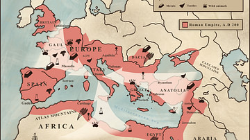
Trade in the Roman Empire Map (c. 200 CE)
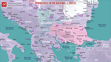
Roman Rule in the Balkans, c. 200 CE

Map of the Trade Routes in the Ancient Mediterranean

Roman Rule in Thrace, c. 200 CE
Cite This Work
APA Style
Netchev, S. (2024, December 05). Map of the Roman Rule in the Levant, c. 200 CE. World History Encyclopedia. https://www.worldhistory.org/image/19754/map-of-the-roman-rule-in-the-levant-c-200-ce/
Chicago Style
Netchev, Simeon. "Map of the Roman Rule in the Levant, c. 200 CE." World History Encyclopedia, December 05, 2024. https://www.worldhistory.org/image/19754/map-of-the-roman-rule-in-the-levant-c-200-ce/.
MLA Style
Netchev, Simeon. "Map of the Roman Rule in the Levant, c. 200 CE." World History Encyclopedia, 05 Dec 2024, https://www.worldhistory.org/image/19754/map-of-the-roman-rule-in-the-levant-c-200-ce/.