

This text is available in other languages:

Roman involvement in North Africa began with the destruction of Carthage in the Third Punic War (149-146 BCE), after which Rome established the province of Africa and gradually expanded its authority across the Maghreb. Over the following centuries, particularly under rulers such as Augustus (reign 27 BCE-14 CE), Claudius (reign 41-54 CE), and Diocletian (reign 284-305 CE), North Africa was reorganized into a network of provinces stretching from Cyrenaica in modern Libya to Mauretania Tingitana in present-day Morocco. This process transformed the region from a frontier of conquest into one of the most stable and strategically important parts of the Roman world.
By the High Empire (1st-3rd centuries CE), North Africa had become a major center of agricultural production, trade, and urban development. Provinces such as Africa Proconsularis, Numidia, and the Mauretanias supplied grain, olive oil, livestock, and tax revenues that helped sustain the wider empire. Roman authority was maintained through a combination of provincial administration, military frontiers, road networks, and alliances with local communities. The region's evolving administrative structure, from senatorial provinces to imperial territories and, later, Diocletian's smaller provincial units, illustrates Rome's ability to adapt its governance to the diverse economic, military, and cultural realities of one of its most prosperous provinces.
About the Author

Related Images

Map of North Africa and the Western Mediterranean c. 1065 - Power Shifts in the Post-Caliphate Maghreb

Map of the Inca Empire - Expansion and Roads
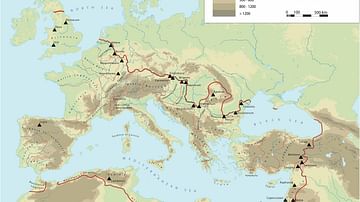
Frontiers of the Roman Empire

Roads of the Roman Empire
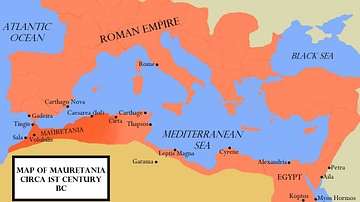
Map of the Kingdom of Mauretania

Map of WWII North Africa Campaign, 1940-1943
Cite This Work
APA Style
Netchev, S. (2026, June 02). Map of Roman North Africa - Provinces, Roads & Frontiers: Expansion, administration & economic foundations 146 BCE–395. World History Encyclopedia. https://www.worldhistory.org/image/16818/map-of-roman-north-africa---provinces-roads--front/
Chicago Style
Netchev, Simeon. "Map of Roman North Africa - Provinces, Roads & Frontiers: Expansion, administration & economic foundations 146 BCE–395." World History Encyclopedia, June 02, 2026. https://www.worldhistory.org/image/16818/map-of-roman-north-africa---provinces-roads--front/.
MLA Style
Netchev, Simeon. "Map of Roman North Africa - Provinces, Roads & Frontiers: Expansion, administration & economic foundations 146 BCE–395." World History Encyclopedia, 02 Jun 2026, https://www.worldhistory.org/image/16818/map-of-roman-north-africa---provinces-roads--front/.