
Server Costs Fundraiser 2026


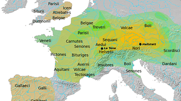
A map illustrating the spread of the Hallstatt culture, a predominant European Late Bronze and Early Iron Age culture from the 12th to 5th centuries BCE. It is generally accepted as a proto-Celtic culture. It is named after Hallstatt, an Austrian village southeast of Salzburg where a multitude of artifacts and burials were discovered.
About the Author

Related Images

Map of the Iron Age La Tène Culture c.400 BCE - c.50 CE
Map of Hallstatt & La Tène Cultures

Map of the Urnfield Culture c. 1300 BCE

Map of Europe After World War II (1945 to c. 1989)

Map of Europe on the Eve of WWII, 1939

Map of the Migration Period in Europe in the 4th-5th Century
Cite This Work
APA Style
Netchev, S. (2021, August 22). Map of the The Hallstatt Culture. World History Encyclopedia. https://www.worldhistory.org/image/14457/map-of-the-the-hallstatt-culture/
Chicago Style
Netchev, Simeon. "Map of the The Hallstatt Culture." World History Encyclopedia, August 22, 2021. https://www.worldhistory.org/image/14457/map-of-the-the-hallstatt-culture/.
MLA Style
Netchev, Simeon. "Map of the The Hallstatt Culture." World History Encyclopedia, 22 Aug 2021, https://www.worldhistory.org/image/14457/map-of-the-the-hallstatt-culture/.