
Search
Remove Ads
Advertisement
Search Results

Definition
Portuguese Angola
Portuguese Angola in southwest Africa was the first European colony on that continent. While settlement from 1571 proved problematic in the interior, the Portuguese did obtain a large number of slaves which they shipped to their Atlantic...

Article
Caesarea Maritima's Role in the Roman Empire
Caesarea Maritima, the city Herod the Great (r. 37-4 BCE) built for Rome on the southeastern coast of the Mediterranean served as the Roman Empire's powerbase of operations both commercially and militarily. With Rome's ultimate goal of adding...

Image
Routes of the Badr Campaign, 624 CE
A map of the troop movements which led to the Battle of Badr, in 624 CE. This map details the movements of the Meccan caravan from Syria, the Muslim raiding party which pursued it, and the Meccan relief force which intercepted the Muslims...

Article
Cultural Links between India & the Greco-Roman World
Cyrus the Great (558-530 BCE) built the first universal empire, stretching from Greece to the Indus River. This was the famous Achaemenid Empire of Persia. An inscription at Naqsh-i-Rustam, the tomb of his able successor Darius I (521-486...

Definition
Kingdom of Kanem
The Kingdom of Kanem (aka Kanim) was an ancient African state located in modern-day Chad, which flourished from the 9th to 14th century CE. With its heartland in the centre of the African continent on the eastern shores of Lake Chad, the...

Definition
Portuguese Malacca
The Portuguese colonised Malacca (modern Melaka) on the southwest coast of the Malay peninsula from 1511 and kept it until 1641 when the Dutch took over. The port controlled the Malay Straits which lead from the Indian Ocean (the Andaman...

Definition
Wolof Empire
The Wolof (aka Jolof or Djolof) Empire was a state on the coast of West Africa, located between the Senegal and Gambia rivers, which thrived from the mid-14th to mid-16th century CE. The empire prospered on trade thanks to the two rivers...
Definition
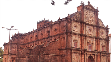
Portuguese Goa
Goa, located on the west coast of India, was a Portuguese colony from 1510 to 1961. The small coastal area was conquered by Afonso de Albuquerque (c. 1453-1515) and became an important trade hub for the Eastern spice trade. Goa was the capital...

Image
Map of the Trade Networks in the Middle Ages, c. 1200
By the early 13th century (c. 1200 CE), long-distance trade networks across Eurasia and the Mediterranean had regained a level of interconnectivity not seen since late antiquity. After the political fragmentation that followed the fall of...

Image
Map of the Roman Trade with the East, c. 1st–3rd Centuries - Silk Roads and Indian Ocean Routes across Afro-Eurasia
Roman trade with the East refers to the overland and maritime exchange networks that connected the Roman Empire with Parthian Iran, the Kushan Empire, India, Southeast Asia, Han China, and, from the 3rd century CE, the Sasanian Empire. During...