
Search
Remove Ads
Advertisement
Search Results
Definition
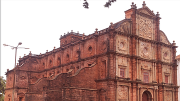
Portuguese Goa
Goa, located on the west coast of India, was a Portuguese colony from 1510 to 1961. The small coastal area was conquered by Afonso de Albuquerque (c. 1453-1515) and became an important trade hub for the Eastern spice trade. Goa was the capital...

Image
Map of the East India Company Trade, c.1800
The English East India Company (EIC) was established by Royal Charter on 31 December 1600 under Queen Elizabeth I (reign 1558–1603), granting it a monopoly on English trade east of the Cape of Good Hope. Initially conceived as a commercial...

Collection
Trade & Commerce in Ancient Greece
The ancient Mediterranean was a busy place with trading ships sailing in all directions to connect cities and cultures. The Greeks were so keen on the rewards of trade and commerce that they colonized large parts of the coastal Mediterranean...

Image
Map of the Hanseatic League Trade Network, c. 1400
The Hanseatic League (c. 13th–17th centuries) was a powerful network of merchant guilds and cities that dominated trade across northern Europe for centuries. Emerging in the late Middle Ages, the League united towns from Lübeck, Hamburg...

Definition
Christopher Columbus
Christopher Columbus (l. 1451-1506 CE, also known as Cristoffa Corombo in Ligurian and Cristoforo Colombo in Italian) was a Genoese explorer (identified as Italian) who became famous in his own time as the man who discovered the New World...

Video
Sacred Sites and Pilgrimage Routes in the Kii Mountain Range (UNESCO/NHK)
Set in the dense forests of the Kii Mountains overlooking the Pacific Ocean, three sacred sites – Yoshino and Omine, Kumano Sanzan, Koyasan – linked by pilgrimage routes to the ancient capital cities of Nara and Kyoto, reflect the fusion...

Article
Ivory & the Colonization of Africa
European colonising powers sought to exploit Africa's resources from the 15th century onwards. Arab traders had been doing the same in North Africa and East Africa through the Middle Ages, but it was from the 17th century that European traders...

Definition
John Hawkins
Sir John Hawkins (1532-1595 CE) was an Elizabethan mariner, merchant and naval administrator who has the inglorious (if not wholly accurate) record of being England's first slave trader. In the 1560s CE Hawkins trafficked slaves from West...

Definition
Ghana Empire
The Ghana Empire flourished in West Africa from at least the 6th to 13th century. Not connected geographically to the modern state of Ghana, the Ghana Empire was located in the western Sudan savannah region (modern southern Mauritania and...

Image
Map of the Trade in the Indian Ocean 15th-16th century - From Afro-Asian Exchange to European Intervention
The Indian Ocean trade network of the 15th and 16th centuries formed one of the most extensive and dynamic systems of exchange in the premodern world, linking East Africa, the Middle East, South Asia, and Southeast Asia. This maritime system...