
Search
Remove Ads
Advertisement
Search Results

Video
Mesopotamia and the Fertile Crescent - A Short History
Mesopotamia is an ancient region in the Middle East, east of the Mediterranean by the Zagros mountains, between the two rivers Tigris and Euphrates. The name ‘Mesopotamia’ comes from the Greek meaning...

Image
Map of the Zulu Kingdom and British Imperial Expansion - The Anglo-Zulu War - Conquest & the Struggle for Power
The Zulu Kingdom emerged in the early 19th century as a centralized and militarized state under Shaka Zulu (reign c. 1816–1828), whose reforms reshaped...
Collection
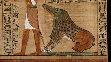
Funerary Rites, Burial, and the Afterlife of the Ancient Egyptians
Often misconstrued as a culture obsessed with death, the ancient Egyptians viewed death and the afterlife as an intimately connected continuance to life itself. Though funerary processions...
Image
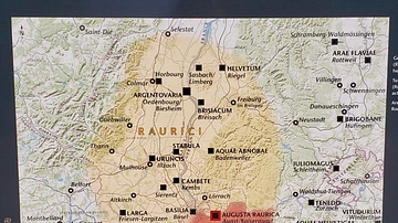
Map of Ancient Raurici Cities and Towns
This is a map of Augusta Raurica and nearby cities in what was formerly Roman Switzerland. These cities and towns were occupied by the Celtic Raurici tribe before and after the Roman conquest of Switzerland...

Image
Map of Mesopotamia and the Ancient Near East, c. 1300 BCE
Map of Mesopotamia and the Ancient Near East c. 1300 BCE, showing the period of Great Powers, with the six large kingdoms and empires (the Hittites, the Mycenaean Civilization, Assyria, Babylonia...
Image
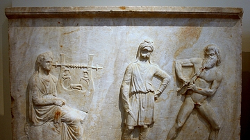
Apollo and Marsyas
National Archaeological Museum, Athens, 215. 330-20 BCE. This relief slab is one of four that made up the revetment of a pedestal (only three survive), and was found at Mantineia, Arcadia. The pedestal either acted as a base...

Image
Altar and Nave of Saint Hripsime Church
The altar and nave of Saint Hripsime Church in Etchmiadzin (Vagharshapat), Armenia. The church dates from the early 7th century CE, and it is one of the finest and most complicated of medieval Armenian churches...

Image
Map of the Area Around Lille and Courtray - Battle Positions at Tourcoing and Pont-à-Chin
This historical map depicts the surroundings of Lille and Courtray and is intended to facilitate the understanding of the Battles of Tourcoing and Pont-à-Chin in 1794...

Image
Three Kingdoms Period of China and the Rise of Xianbei in the year 229 CE
This map depicts the boundaries of all major civilizations in East Asia at the beginning of the Three Kingdoms Period of China, with italics indicating nomadic bands and other tribal...

Image
The Magonids and other Prominent Carthaginians
This family tree shows all the rulers of Carthage mentioned in extant ancient Greek and Roman sources (and three from a Punic inscription) from circa 550 to 306 BCE. It also indicates the Carthaginian commanders...
