
Server Costs Fundraiser 2026


This historical map depicts the surroundings of Lille and Courtray and is intended to facilitate the understanding of the Battles of Tourcoing and Pont-à-Chin in 1794. It shows the positions of the armies involved during these engagements, providing a geographic framework for analyzing military operations in the region. Source: Votre Carte Ancienne – antique maps of France.
About the Author

Related Images
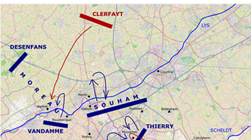
Battle of Tourcoing, First Day
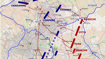
Allied Plan of Attack for the Battle of Tourcoing
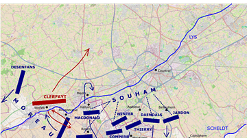
Battle of Tourcoing, Second Day
Map of Shark Bay Area Showing Dirk Hartog Island and Cape Inscription

Map of the Movement of "Tea" & "Cha" Around the Globe

The Route of the St Jean Baptiste and the Endeavour around the North Cape of New Zealand
Cite This Work
APA Style
Denis, L. (2025, May 23). Map of the Area Around Lille and Courtray: Battle Positions at Tourcoing and Pont-à-Chin. World History Encyclopedia. https://www.worldhistory.org/image/20469/map-of-the-area-around-lille-and-courtray/
Chicago Style
Denis, Léopold. "Map of the Area Around Lille and Courtray: Battle Positions at Tourcoing and Pont-à-Chin." World History Encyclopedia, May 23, 2025. https://www.worldhistory.org/image/20469/map-of-the-area-around-lille-and-courtray/.
MLA Style
Denis, Léopold. "Map of the Area Around Lille and Courtray: Battle Positions at Tourcoing and Pont-à-Chin." World History Encyclopedia, 23 May 2025, https://www.worldhistory.org/image/20469/map-of-the-area-around-lille-and-courtray/.