
Search
Remove Ads
Advertisement
Search Results

Image
Map of the Roman Trade with the East, c. 1st–3rd Centuries - Silk Roads and Indian Ocean Routes across Afro-Eurasia
Roman trade with the East refers to the overland and maritime exchange networks that connected the Roman Empire with Parthian Iran, the Kushan Empire...

Image
Eight Major Military Failures - Ambition, Limits, and Collapse in Warfare
An infographic of eight major military failures through history. Across history, significant military campaigns have often begun with overwhelming force and confidence in rapid success...

Image
Ancient Mesopotamia from Cities to Empires
The long-term development of Mesopotamia traces one of the earliest and most influential trajectories in world history, spanning from small Stone Age settlements (c. 10,000 BCE) to the political and cultural...

Image
Map of the African Slave Trade Networks, c. 1750 - Atlantic, Trans-Saharan, Red Sea & Indian Ocean Routes
By c. 1750, the slave trades affecting Africa were entering a period of major transformation. Long-established trans-Saharan, Red Sea, and Indian Ocean networks...

Image
The Twelve Longest Discovery Expeditions in the Age of Sail - Exploration, Science, and the Expansion of Global Knowledge
The Age of Sail (c. 1400–1860) produced some of history’s longest exploratory and scientific expeditions, driven by trade, imperial rivalry, navigation...

Image
Map of Early Human Migrations
This map illustrates the early global migrations of Homo sapiens—our species’ remarkable journey from Africa to every inhabitable continent. Tracing movements that began over hundreds of thoussands of years ago, it...

Collection
The Fall of Civilizations
It seems that civilizations inevitably rise and fall no matter how big or small, and in this collection, we look at some of the most famous, spectacular, and mysterious collapses of cultures from the Romans to the Maya...

Image
Roman Roads: Engineering an Empire - Construction, Mobility & Imperial Power
Roman roads were an extensive system of overland routes developed, expanded, and maintained across the Roman world to connect cities, ports, military zones, and provincial centers...
Image
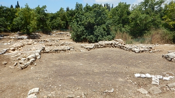
Ceremonial Hall 611, Tel Kabri
The ceremonial hall at Tel Kabri as it appeared in 2015 CE. The hall was constructed c. 1720 BCE as part of the second phase of Tel Kabri's Middle Bronze Age Canaanite palace. It is believed to have served as the focal...

Image
Mimbres Ceramic Vessel
This Mimbres vessel dates from 1000-1150 CE. The Mimbres, a Mogollon group, lived near the Mimbres River in a mountainous area in the southwest corner of New Mexico from c. 1000-1250 CE. Their clay vessels display a major...
