
Search
Remove Ads
Advertisement
Search Results

Image
Gates of the Prophet's Mosque, Medina
Photo of the inscription on the gates of the Mosque of the Prophet (Arabic: Al-Masjid an-Nabawī) in Medina, Saudi Arabia. The inscription has the name of Prophet Muhammad, followed by his title "the apostle of God". A black vignette has...
Image
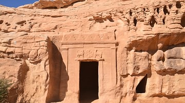
The Lion Tomb, Hegra
The Lion Tomb is located in the Qasr al-Bint Nabataean Necropolis of Hegra (now in Saudi Arabia). The façade of the tomb is decorated with a carving of two felines on either side of a rosette. The name of the stonemason who carved the tomb...

Video
Petra (UNESCO/NHK)
Inhabited since prehistoric times, this Nabataean caravan-city, situated between the Red Sea and the Dead Sea, was an important crossroads between Arabia, Egypt and Syria-Phoenicia. Petra is half-built, half-carved into the rock, and is surrounded...

Video
Faces of Ancient Near Eastern Women
This video is a slideshow of pictures of various artifacts and artworks that detail the visage of ancient Near Eastern women, most of which are royalty. Locations include: Mesopotamia (Sumer and Akkad), Arabia, Phoenicia (Lebanon) and Elam...

Book Review
The Food of Oman: Recipes and Stories from the Gateway to Arabia
While most people think of Middle Eastern cuisine, images of “Persian,” “Turkish,” or “Lebanese” food immediately come to thought. Set between the crossroads of East Africa, South Asia, the Middle East, and the Spice Islands, the Sultanate...
Image
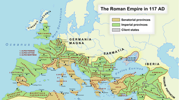
Roman Empire in 117 CE
Map of the Roman Empire at its maximum extent in 117 CE, under the rule of Trajan.
Image
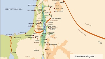
Map of the Nabatean Kingdom
Map of the Nabatean Kingdom at its greatest extent, c. 85 BCE.

Image
Map of the Levant
This map shows the place of the Levant (highlighted in red) within the eastern Mediterranean.

Image
Map of the Ptolemaic World
A map showing the known world at the time of the Ptolemaic Empire, ca. 300 BC.
Image
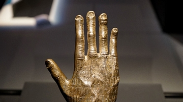
Arabian Bronze Hand
This bronze hand was found in Yemen (100-300 CE). The inscription on the hand asks for good fortune for the devotee Ta'lab. This image was taken at the National Museum of Australia in the travelling exhibition A History of the World in...