
Search
Remove Ads
Advertisement
Search Results

Article
Causes of the American Civil War - Spoiler Alert: It Was All About Slavery
There was actually only one cause for the American Civil War: slavery. All the events leading to the Civil War, understood as steps moving steadily up the conflict, had slavery as the underlying cause for upset and increasing division between...

Article
US Involvement in WWI - From Isolationism to Military Intervention
The United States remained neutral in the first three years of the First World War (1914-18) but did finally join the conflict at the end of 1917 following the threat of unrestricted submarine warfare on US merchant shipping and a secret...
Definition
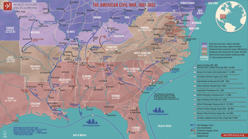
American Civil War - The Birthpangs of the United States
The American Civil War (1861-1865) was the pivotal event in United States history and the largest armed conflict in the Western world following the end of the Napoleonic Wars (1815) and prior to the beginning of the First World War (1914...

Definition
Diet of Worms
The Diet of Worms (January-May 1521) was the assembly convened by Charles V, Holy Roman Emperor to address, among other issues, the works of the reformer Martin Luther (l. 1483-1546) who openly criticized the Church. Luther was told to recant...

Image
The United States Constitution, 1787
The United States Constitution (1787) represents the foundational legal and political framework of the American republic, drafted to replace the ineffective Articles of Confederation (1781) and unify the newly independent states under a stronger...

Image
Map of the United States, 1874
A map of the United States, showing each of its states, published by D.G. Beers & Co. in 1874.
From the Lionel Pincus and Princess Firyal Map Division, The New York Public Library.

Image
Map of the Warring States of China & Qin Conquest
The Warring States period (c. 475–221 BCE) represents the final and most transformative phase of the Eastern Zhou dynasty (770–256 BCE), marked by political fragmentation, sustained interstate warfare, and profound institutional change. As...

Image
Map of the Crusader States (Outremer), 1096-1291
The Crusader States, collectively known as Outremer (from Old French outre-mer, “overseas”), were a group of Latin Christian polities established in the eastern Mediterranean following the First Crusade (1096–1099). Emerging from the conquest...

Article
Unam Sanctam: Spiritual Authority & the Medieval Church
The Unam Sanctam (1302) was a papal bull issued by Pope Boniface VIII (served 1294-1303) requiring the complete submission of all people, including kings, to the authority and dictates of the pope. As the Church was understood as holding...

Article
Medieval Indulgence & Martin Luther
The medieval indulgence was a writ offered by the Church, for money, guaranteeing the remission of sin, and its abuse was the spark that inspired Martin Luther's 95 Theses. Luther (l. 1483-1546) claimed the sale of indulgences was unbiblical...