
Search
Remove Ads
Advertisement
Search Results

Image
Map of the United States Under the Compromise of 1850
This map illustrates the situation in the United States n 1850, as the country faced growing sectional tension over the expansion of slavery into new territories gained from the Mexican-American War. The Compromise of 1850 aimed to preserve...

Definition
Dred Scott Decision - Worst Supreme Court Ruling in US History
The Dred Scott Decision (Dred Scott v. Sandford, 60 U.S. (19 How.) 393 (1857) was the infamous ruling of the United States Supreme Court that, according to the US Constitution, Black people were not and could not be considered citizens of...
Image
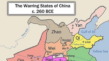
Chinese Warring States, 3rd century BCE
A map showing the principle state of the Warring States Period in China c. 260 BCE.

Image
Indian Princely States Postage Stamps
Four examples of British India postage stamps issued with overprints for use in particular Indian princely states. Top left: Queen Victoria, Gwalior, 1904 Top right: Queen Victoria, Patiala, 1895 Bottom left: King George V, Jind State...

Image
Map of the Trojan War States, c. 1200 BCE
The Bronze Age collapse at the end of the 13th century BCE saw a great many changes in the ancient world. Many second millennium states disappeared entirely, as cities were destroyed and peoples migrated. Others underwent a process of transformation...

Image
Warring States Helmet
A bronze helmet from the Yin state. Warring States Period (481-221 BCE).

Image
Warring States Period Swords
Swords of the Warring States Period (481-221 BCE) in China. The left sword is of iron while the other two are of bronze. (Shaanxi Provincial Museum, Xian, China)

Image
Warring States Crossbow Trigger
The trigger and firing mechanism of a crossbow from the Chinese Warring States Period, 3rd century BCE (possible a century later during the Han Dynasty). Bronze inlaid with silver.

Image
Map of Ancient & Medieval Sub-Saharan African States
A map indicating the major ancient and medieval states in sub-Saharan Africa. Areas and dates relate to a state at its peak. In addition, shaded areas are approximate indicators only. For the majority of the states, their precise borders...

Image
Map of the Greek City-states c. 500 BCE
This map illustrates the city-states of Classical Greece around 500 BCE, highlighting the rise of the polis system and the growing reach of Hellenic influence along the Mediterranean and Black Sea coasts. The period saw Athens and Sparta...