
Search
Remove Ads
Advertisement
Search Results
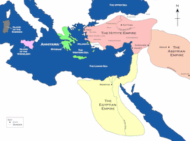
Image
Map of the Hittite Empire and Surrounding States
A map of the Hittite Empire and surrounding states, including the Assyrian Empire, the Egyptian Empire, and Ahhiyawa.
This map is an extract from the book Empires of Bronze by Gordon Doherty, republished with permission.

Image
Map of the Crusader States, 1229-1240 CE
A map indicating the territories controlled by the Crusader States or Latin East from 1229 CE to 1240 CE after the Sixth Crusade (1227-1229 CE)
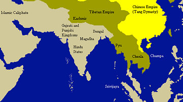
Image
Tang Empire & Neighbouring States
A map indicating the extent of the Tang empire (618-907 CE) and its neighbouring states and tribes people.

Image
Kushan Empire & Neighboring States
This map shows the extent of the Kushan empire along with the various states and kingdoms that surrounded it at roughly the same time period. c. 100 - 240 CE.

Image
Map of Ancient Georgian States (600-150 BCE)
Map showing the ancient states in the western Caucasus (modern-day Georgia) from c. 600 BCE to 150 BCE.

Image
Scene at the Signing of the Constitution of the United States
A scene at the signing of the US Constitution, oil on canvas painting by Howard Chandler Christy, 1940.
United States Capitol, Washington, D.C.

Image
The Declaration of Independence of the United States of America
The Declaration of Independence of the United States of America, July 4, 1776, oil on canvas by Charles Édouard Armand-Dumaresq, c. 1873.
White House Cabinet Room, Washington, D.C.

Image
Map of Korean States in 108 BCE
A map of the Korean states in 108 BCE.
Image
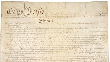
Constitution of the United States
Constitution of the United States, 17 September 1787.
National Archives and Records Administration, Washington D.C.
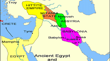
Image
States of the Fertile Crescent, c. 1450 BCE
A map illustrating the various political states within the Fertile Crescent c. 1450 BCE.