
Search
Remove Ads
Advertisement
Search Results

Interview
Interview with Greg Woolf
Join World History Encyclopedia as they talk to author and professor Greg Woolf all about his book Rome: An Empire's Story, Second Edition, published by Oxford University Press. Kelly (WHE): Do you want to just tell everyone what the book...

Image
Map of North Africa and the Western Mediterranean c. 1065 - Power Shifts in the Post-Caliphate Maghreb
Around 1065, the geopolitical landscape of North Africa and the western Mediterranean was marked by fragmentation, migration, and the rise of new regional powers. Older political structures were weakening, while emergent dynasties and mobile...

Image
Routes of the Barbarian Invaders
Routes of the Barbarian invaders into the Roman Empire during the Migration Age.
Image
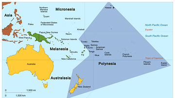
Map of Polynesia
Map showing the Polynesian Triangle and some of its islands.

Image
Map of India in the Vedic Age, 1500 BCE-500 BCE - Indo-Aryan Cultures in Northern India
The Vedic Age (c. 1500-500 BCE) marks a formative period in the history of the northern Indian subcontinent, bridging the decline of the Indus Valley Civilization (c. 1300 BCE) and the emergence of early states in the Gangetic plain. During...

Image
Map of the Scythian Expanse, c. 700-300 BCE
The westward expansion of the Scythians (c. 700–300 BCE) illustrates how mobile steppe societies could reshape the political and cultural landscapes of Eurasia without building territorial empires. Originating in the Central Asian steppes...
Image
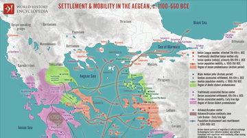
Map of Settlement & Mobility in the Aegean, c. 1100-550 BCE - Migration, Memory, and the Making of the Greek World
The period following the collapse of the Mycenaean palatial system (c. 1200–1100 BCE) saw profound demographic and cultural reorganization across the Aegean. During the so-called Greek “Dark Age” (c. 1100–800 BCE), communities fragmented...

Image
Bantu Farmers
This artist's illustration shows Bantu farmers using slash-and-burn agriculture to clear arable land. Created by Amplitude Studios for the video game Humankind.
Image
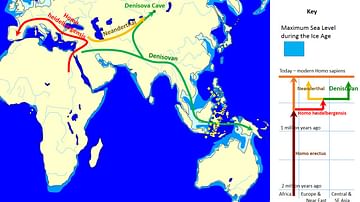
Spread and Evolution of Denisovans
Map showing a possible scenario of the spread and evolution of Denisovans. On the right, it shows that Homo sapiens shares a common ancestor with the Neanderthals and Denisovans, who are sister species. There is evidence of interbreeding...
Image
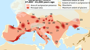
Aurignacian Sites
Map showing sites and presence associated with the Aurignacian culture, usually attributed to the first modern humans who arrived in Europe around 45,000 years ago.