
Search
Remove Ads
Advertisement
Search Results
Image
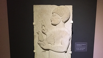
Lydian Relief: 5th Century BCE
This relief of a male holding a bird is from the 5th century BCE, found in modern day western Turkey near the ancient city of Thyatira. Thyatira was named such by Seleucos I Nicator around 290 BCE but prior to that it was an important city...

Image
19th-Century Christmas Card
A late-19th century Christmas card showing a robin and snow scene. The border is perforated to resemble lace. (Victoria and Albert Museum, London) Orignal source note on usage: 'V&A Owned Content' in which the V&A owns copyright (or related...

Image
Hydria (4th century BCE)
The hydria, as its name indicates, was used almost exclusively for carrying water (Greek hydor), essential for everyday cleansing, ritual purifications and libations. 4th-century BCE. Made from bronze. (Hellenic Museum, Melbourne, Victoria)

Image
Janissary Uniform, Early 19th Century
Illustration of a Janissary's uniform, drawing by John Heaviside Clark, included in Thomas McLean's The Military Costume of Turkey. Illustrated by a Series of Engravings, from Drawings Made on the Spot, plate 5, 1818. This image of an early...

Image
Map of the First Three Crusades & the 12th-Century Outremer
These maps illustrate the trajectory of the early Crusades (1096–1192), a series of military campaigns launched by the medieval Latin Church with the declared goal of reclaiming the Holy Land—centered between the Mediterranean Sea and the...

Image
11th century CE Kievan Rus Territories
Map of Kievan Rus territories during the feudal split, after the death of Prince Yaroslav the Wise in 1054 CE.

Image
The Military Crusader Orders, 11-13 Century
An infographic showing the Military Crusader Orders which emerged as unique institutions blending monastic devotion with martial duty. Founded in the wake of the First Crusade (1096–1099), their primary purpose was to protect pilgrims and...

Image
Anglo-Saxon Clothing, 6-9th century CE
An illustration of the typical clothing worn by Anglo-Saxons in medieval England, c. 500 - c. 1000 CE. ('Costumes of all Nations', 1882 CE)
Image
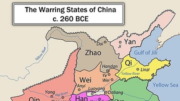
Chinese Warring States, 3rd century BCE
A map showing the principle state of the Warring States Period in China c. 260 BCE.

Image
Map of Celtic Expansion - 6th-3rd century BCE
A map showing the various campagins of Celtic tribes between the 6th and 3rd centuries BCE.