
Search
Search Results
Image
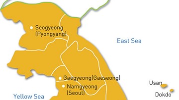
Map of the Goryeo Empire (11th century CE)
A map of the territory controlled by the Goryeo Dynasty of Korea in the 11th century CE. The Goryeo reigned from 918 to 1392 CE.
Image
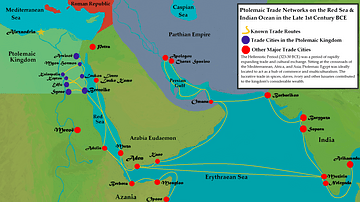
Ptolemaic Trade Networks in the Late 1st Century BCE
This map illustrates the trading networks which connected the Ptolemaic Kingdom to South Asia and East Africa by the second half of the 1st century BCE. During this time period, Ptolemaic Egypt was a major player in the spice trade which...
Image
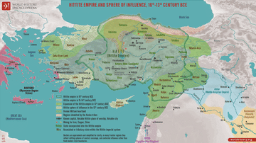
Map of the Hittite Empire 16th-13th Century BCE - Anatolian Great Power of the Bronze Age
The Hittite Empire emerged in central Anatolia during the early second millennium BCE and developed into one of the major powers of the Late Bronze Age. Centered on Hattusa, it ruled over a culturally diverse realm rooted in the older land...

Image
Knights in Armour, 15th century CE
Knights in armour typical of the 15th century CE. (Metropolitan Museum of Art, New York)

Image
16th century CE Desk with Lute, Globe and Books
A detail of a mid-16th century CE painting by Hans Holbein the Younger showing a desk with a lute, globe and books. From 'The Ambassadors', c. 1533 CE. (National Gallery, London)

Image
15th-century CE Ottoman Cannon
A 15th-century CE bronze Ottoman cannon based on the design of those used in the siege of Constantinople in 1453 CE by Mehmed II.

Image
Map of France, 10th Century CE
A map of France in the 10th century CE.

Image
European 16th Century Armour
Typical weapons and armour used in European warfare in the 16th century and by conquistadors in the New World. (Grand Master's Palace Armoury, Valletta, Malta)

Image
Roman Forum in the 5th Century BCE
A painting of the Roman Forum as it probably would have appeared in the 5th Century BCE. By Vilius Petrauskas.
Courtesy of Ancient History Magazine / Karwansaray Publishers.

Image
The South China Sea in the 18th Century
A late-18th century map of the South China Sea. Drawn by Rigobert Bonne and G. Raynal