
Search
Search Results

Image
Map of the Trade in the Indian Ocean 15th-16th century - From Afro-Asian Exchange to European Intervention
The Indian Ocean trade network of the 15th and 16th centuries formed one of the most extensive and dynamic systems of exchange in the premodern world, linking East Africa, the Middle East, South Asia, and Southeast Asia. This maritime system...

Image
Map of the Migration Period in Europe in the 4th-5th Century
The Migration Period in Europe (c. 4th–6th centuries CE) marks a prolonged era of movement, conflict, and political transformation rather than a single moment of collapse. Following the death of Emperor Theodosius I (reign 379–395 CE) and...

Image
Map of the Parthian Empire in the 2nd Century
This map illustrates the Parthian Kingdom (c. 247 BCE–224 CE), also known as the Arsacid Empire after its ruling dynasty. Emerging on the northeastern fringes of the Seleucid realm, the Parthians expanded their power as Seleucid control weakened...
Image
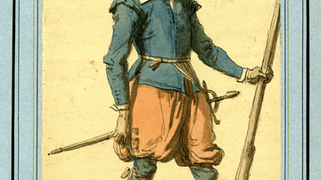
17th-Century Musketeer
A drawing of a typical 17th-century musketeer. Musketeers were a standard component of European infantry armies of the period and particularly during the English Civil Wars (1642-51). Ink and watercolours. Drawn in the 19th century. (British...
Image
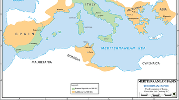
Map of 2nd Century Roman Expansion
A map showing the early expansions of Rome, in the 2nd century BC.

Image
Map of Japan in the 16th Century CE
A map of Japan during the Azuchi-Momoyama period (1568-1600 CE).

Image
Map of Viking Exploration, 8th-11th Century
This map illustrates the sweep of Viking exploration between the late 8th and early 11th centuries, charting longship routes from Scandinavia to the British Isles, Normandy, Iberia, Russia, the Mediterranean, and across the North Atlantic...

Image
Map of the Hellenic Leagues and Hegemonies, 4th century BCE
The political landscape of the Hellenic world shifted dramatically in the aftermath of the Peloponnesian War (431–404 BCE), a conflict that ended with Sparta’s victory but left the Greek city-states militarily exhausted and politically fragmented...
Image
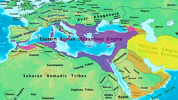
Byzantine & Persian Empires in the 7th Century
A map showing the extent of the Byzantine Empire and the Sasanian Empire in the 7th century.

Image
17th-century Depiction of Plague Doctor
A depiction of "Doctor Schnabel" ("Schnabel" is literally German for "Beak"), a plague doctor in Rome. The illustration appeared in a 17th -century German satirical manuscript. The engraving was first published by Paul Fürst (1608–1666...