
10 days left
Server Costs Fundraiser 2026
It costs $20,000 a year to run our servers, and we need your help to pay for them!
$10697 / $20000


Related Images
Image
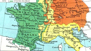
Division of the Carolingian Empire in 843 & 870 CE
Map of the Carolingian empire following its division in the 9th...

Image
Map of the Carolingian Empire under Charlemagne, c. 814
The rise and expansion of the Carolingian dynasty (8th–early 9th...

Image
Division of the Carolingian Empire in 898
Map of the former Carolingian Empire in 898 following its collapse...
Image
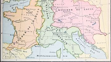
Division of the Carolingian Empire
Map of the Carolingian Empire following its division in 843 by...
Image
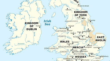
British Isles at the Beginning of the 10th Century
British Isles in 10th century represented with the coastline at...

Image
Map of The D-Day and the Normandy Landings, June 1944 - Operation Overlord & History's Largest Amphibious Invasion
The Allied landings in Normandy on 6 June 1944, commonly known...
Cite This Work
APA Style
Cyberprout, B. -. (2018, November 08). Map of France, 10th Century CE. World History Encyclopedia. https://www.worldhistory.org/image/9415/map-of-france-10th-century-ce/
Chicago Style
Cyberprout, Bourrichon -. "Map of France, 10th Century CE." World History Encyclopedia, November 08, 2018. https://www.worldhistory.org/image/9415/map-of-france-10th-century-ce/.
MLA Style
Cyberprout, Bourrichon -. "Map of France, 10th Century CE." World History Encyclopedia, 08 Nov 2018, https://www.worldhistory.org/image/9415/map-of-france-10th-century-ce/.