
Browse Content
Image
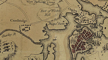
Map of Boston, 1775
A map of Boston and the surrounding country in 1775, during the...

Image
Map of a Circumnavigation of the Black Sea c. 130 CE - Arrian of Nicomedia's "Periplus Ponti Euxini"
The Periplus Ponti Euxini (“Circumnavigation of the Black Sea”...
Image
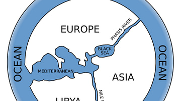
Anaximander World Map
The Greek philosopher Anaximander of Miletus (l. c. 610 to c. 546...

Image
Map of the Hellenic Leagues and Hegemonies, 4th century BCE
The political landscape of the Hellenic world shifted dramatically...

Image
Map of the Scientific Voyages of Edmond Halley (c.1676–1721)
The travels of Edmond Halley (1656–1742) exemplify the expanding...

Image
Map of the World War I in Europe, May 1917
A map illustrating the situation in Europe around May 1917, during...