


A map of Boston and the surrounding country in 1775, during the time of the Battles of Lexington and Concord and the Battle of Bunker Hill. By J. DeCosta, 29 July 1775.
Library of Congress Geography and Map Division, Washington D.C.
Related Images

Map of the American Revolutionary War, 1775–1783 - Campaigns, Battles & Naval Power in the War for Independence
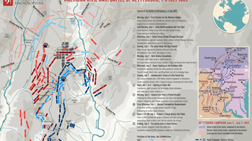
Map of Battle of Gettysburg during the American Civil War
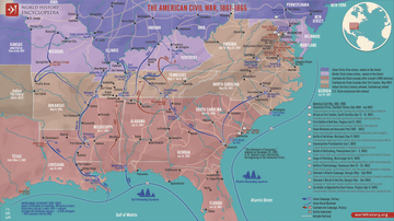
Map of the American Civil War, 1861-1865

Battles of the Genpei War

Map of the British-American War of 1812

The "Spring of Nations": Revolutionary Europe in 1848 - From Revolution to Reaction: Nationalism and Upheaval in Nineteenth-Century Europe
Cite This Work
APA Style
DeCosta, J. (2023, December 18). Map of Boston, 1775. World History Encyclopedia. https://www.worldhistory.org/image/18273/map-of-boston-1775/
Chicago Style
DeCosta, J.. "Map of Boston, 1775." World History Encyclopedia, December 18, 2023. https://www.worldhistory.org/image/18273/map-of-boston-1775/.
MLA Style
DeCosta, J.. "Map of Boston, 1775." World History Encyclopedia, 18 Dec 2023, https://www.worldhistory.org/image/18273/map-of-boston-1775/.