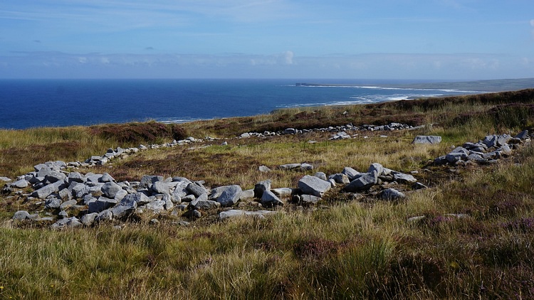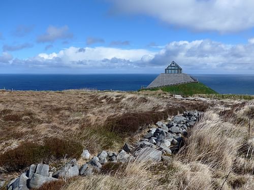
The Ceide Fields, near Ballycastle, Co. Mayo, on the western coast of Ireland, are recognised as one of the oldest and largest Stone Age farming sites in the world, dating back to c. 3700 BCE. The walls that have been discovered so far, rest under a growing blanket bog covering approximately 5 square miles (12.9 sq. km), and the exact size of the site is still undetermined. The fields cover the remains of hundreds of stone age farms, recognised by the sets of parallel walls, some reaching over a mile (1.6 km) long. These long walls are divided into rectangular plots, marking farming communities. Although the fields were found in the 1930s CE, it was not until the 1970s CE that excavation began. Today, the remains of most of the walls are still underground, hidden under the blanket bog, making excavation difficult.
Introduction of Farming
It was c. 7000 BCE, during the Mesolithic period that the first settlers arrived in Ireland. With the Mesolithic period dating from c. 7500 BCE to c. 4500 BCE, the Neolithic period is characterised by major changes in human development. By c. 3700 BCE hunting in Ireland had been replaced by farming. Settlements could now remain in a permanent location, forming farming communities. Certain animals such as bears and wild pigs were present in Ireland during the Mesolithic period, but since there were no sheep and cattle, they must have been carried across to Ireland by boat. There are two common theories as to who brought these animals across.
Firstly, these farmers could have been immigrants, who moved from Europe to Britain and then to Ireland, bringing animals and crops such as wheat and barley with them by boat. Alternatively, they could have been Irish traders or fishermen who travelled overseas during the Mesolithic period, witnessing foreign farming practices and taking crops and animals back with them. Cattle were imported to Ireland in significant numbers and would have made up the original breeding stock for the millions of cattle found in the country today.
Discovery & Excavation
It is due to the interest of local schoolmaster, Patrick Caulfield, that the walls were discovered in the 1930s CE, near Ballycastle, Co. Mayo. He noticed a large chunk of pine in the family bog that seemed out of place and talked to some of his neighbours who wondered why they had been hitting a hard surface while they were out cutting for peat. After having a better look, he discovered traces of a wall stretched out in long lines under the bog. Writing to Adolf Marr, Director of the National Museum of Ireland, Patrick described the remains as:
Similar to those found around the country and are similar to stone circles, old graves, forts and what I think have been ancient pathways or bog defences beneath the bog. (The Man Who Found Ceide)
Members of the National Museum were not willing to travel across the country to see the site, especially during the World War II Emergency when the rationing of petrol was a problem. It was due to the work of Patrick's son Seamus, that excavation finally began in 1969 CE. He detected and mapped out the walls with the help of some of his students. This was done by inserting long iron poles into the bog to locate any hard surfaces. Bamboo rods were then placed in the ground and left there to mark out any of these points, maybe a wall or tree. A pattern of long, crossing walls began to show.
Farming Community of the Ceide Fields
The large size of the plots and surrounding stone walls suggest that they were primarily used for livestock farming. Cattle bones have also been discovered, indicating herds of about 50, grazing over plots of about 30 acres. Most of the Neolithic cattle remains found at the Ceide Fields and throughout Ireland, indicate that cattle were slaughtered by the time they reached 3 to 4 years old. This indicates that they were bred primarily for meat, rather than dairy products.
There is evidence that grain was grown in some of these fields, too, often using cow manure as a fertilizer. Plough marks have been recorded, and artefacts found during excavation include two stone tips of broken ards (the earliest form of the plough). Also, a saddle quern used to grind grain by rubbing a smooth stone back and forth on top of a larger one.
Although the walls are not defensive in nature, this does not necessarily mean that the people of Ceide Fields were living in a peaceful environment. It could just mean that the defensive walls have not been found yet. This is one of the mysteries that further excavation could solve. Larger, thicker walls or tower foundations could indicate than protection was necessary, but they could be hidden underground miles away.
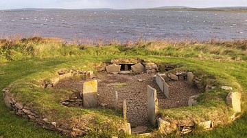
The residents here, seem to have lived on family farms that included fields, housing, and tombs. It is believed that houses were typically round, measuring approximately six meters across. This is based on the discovery of an oval-shaped stone enclosure that has been found on the site. Although there is disagreement as to whether it was used as a house or a cattle compound, spreads of charcoal and a series of postholes, probably used for roof support, have convinced many that it was originally a house.
The community must have worked together to create these fields. Hundreds of people would have been needed, not just to build the walls but also to clear the site before construction began. This required the cutting down of approximately 250,000 trees, covering over 2,500 acres of land. The growth of trees is a good indication that a piece of land is fertile for farming. The seeds and pollen found at the site have been used to work out the date these trees were cut down, c. 3700 BCE. A number of flint and porcellanite axe-heads have been found at the site. Porcellanite was a more durable material which could have cut down several trees. These heavier polished axe-heads would be more suitable for ring-barking and tree-felling.
Abandonment
The land was intensively farmed for approximately 500 years, c. 3700 BCE to c. 3200 BCE. Residents were probably forced to leave due to bog formation, and there are several theories as to why it first started to form. As trees pull water out of the ground through their roots, emitting it out through their leaves, one effect of cutting them down is an increase in water entering the soil. When the ground is very wet, dead plants are more likely to pile up, forming peat.
Climate change is another theory. We know that 5,000-6,000 years ago, temperatures on the Northern Hemisphere were higher, recognized today as being caused by slow changes in the earth's orbit. When temperatures later began to fall, there was also an increase in the level of rainfall, making it less likely that the soil would dry out and encouraging the growth of peat. It is not known when these bogs began to form but it seems that the people in the community were forced to leave. One theory is that the prolonged use of this land led to soil impoverishment, but it is likely due to the development of these bogs, that they had no other choice but to move.
Modern Celebration of the Ceide Fields
Since the first excavations Seamus Caulfield continued to encourage the local communities to get involved in raising money, believing that the site could be turned into a major tourist attraction. Sean Smyth of the Mayo County Development Team admired Seamus for his dedication to the project and contributed money to make a promotional video. In this video, Prof. Martin Downs talks about Ceide Fields, describing them as an archaeological site of 'world importance'.
Holding meetings with local communities and farmers, Seamus encouraged different towns to raise money by setting up fundraising events. For example, local children in Doohoma, Co. Mayo went around door to door collecting money. It added up but they still needed more, about €650,000 ($761,000) from more substantial donors. When the Irish Taoiseach Charles Haughey flew out to the Ceide Fields in 1990 CE, he stated:
An illumination of antiquity on par with anywhere else in the world. What we must do is deal with it imaginatively, sensibly and profitably. (The Man who found Ceide)
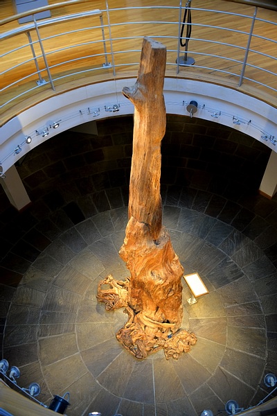
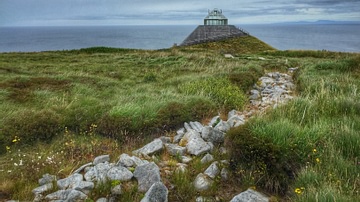
Haughey pledged money for the creation of a visitor's centre, and in 1993 CE the Ceide Fields Interpretative Centre was opened, which received the Europa Nostra Diploma of Merit in 1997 CE. This impressive pyramid-shaped building is a 60 feet (18 m) high, multi-award-winning centre. The 4,000-year-old pine tree unearthed from the nearby bogland makes a stunning centrepiece. The visitor's centre explains the background and the archaeology of the fields, the ecological value of the bogs, what they are, how they could have formed, and how they have been used to work out the age of the site. It also looks at the geology of north Mayo and the landscape today.
Conclusion
Today, hundreds of square miles in Co. Mayo are made up of blanket bogs, making it the least populated area of the country. It can be compared to a desert made of soil, instead of sand. Although much of the Ceide Fields is still uncovered, they make up a unique, rural site of international importance. The site overlooks the Atlantic Ocean, with impressive views reaching out across the cliffs and onto the sea. Most people who travel to the Ceide Fields today, go there to explore the site, and the entire area is open for the public to observe. Tours of the excavation sites are given, with some of the walls exposed for visitors to look at. Bamboo rods stand in the parts of the site that have not been excavated yet, indicating the shape of the walls underneath the bog. Although many unanswered questions remain, further excavation will hopefully answer some of them.

