
Server Costs Fundraiser 2026


A map of the Kingdom of Northumbria (c. 604-954 CE) in the northeast of Britain c. 802 CE.
Related Images

Map of the New Kingdom of Egypt, 1450 BCE
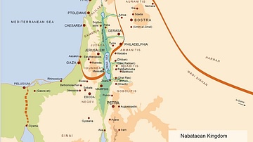
Map of the Nabatean Kingdom

Map of the Bosporan Kingdom, c.100 CE - Gateway Between Steppe, Caucasus, and Rome

Map of the Ptolemaic Kingdom of Egypt c. 240 BCE - Power, Wealth, and Rivalry in the Hellenistic World

Map of the Middle Kingdom of Egypt, c. 2000 BCE

Map of Kingdom of Axum
Cite This Work
APA Style
Bjorklid, F. (2018, November 29). Map of the Kingdom of Northumbria. World History Encyclopedia. https://www.worldhistory.org/image/9608/map-of-the-kingdom-of-northumbria/
Chicago Style
Bjorklid, Finn. "Map of the Kingdom of Northumbria." World History Encyclopedia, November 29, 2018. https://www.worldhistory.org/image/9608/map-of-the-kingdom-of-northumbria/.
MLA Style
Bjorklid, Finn. "Map of the Kingdom of Northumbria." World History Encyclopedia, 29 Nov 2018, https://www.worldhistory.org/image/9608/map-of-the-kingdom-of-northumbria/.