


A map indicating the location and extent of the Antonine Wall (140s CE) and Hadrian's Wall (122 CE).
Related Images

Map of the Hadrian’s wall (Vallum Hadriani) c. 122 CE

Map of the Roman Rule in Britain c. 43 - 410 CE - Four Centuries of Empire at the Edge of the World

Map of the Travels of Hadrian & the Roman Empire c. 125 CE
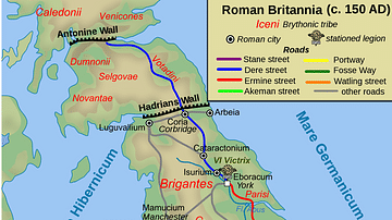
Map of Roman Britain, 150 AD

The Journey of Hadrian 121-125 CE - An Emperor on the Move: Defense and Diplomacy in the Roman World

Cities Founded or Renamed in Hadrian’s Name (117 -138 CE)
Cite This Work
APA Style
Einstein, N. (2016, December 12). Map Indicating the Antonine & Hadrian Walls. World History Encyclopedia. https://www.worldhistory.org/image/6131/map-indicating-the-antonine--hadrian-walls/
Chicago Style
Einstein, Norman. "Map Indicating the Antonine & Hadrian Walls." World History Encyclopedia, December 12, 2016. https://www.worldhistory.org/image/6131/map-indicating-the-antonine--hadrian-walls/.
MLA Style
Einstein, Norman. "Map Indicating the Antonine & Hadrian Walls." World History Encyclopedia, 12 Dec 2016, https://www.worldhistory.org/image/6131/map-indicating-the-antonine--hadrian-walls/.